

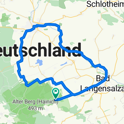
Tour durch den Nationalpark Hainich mit Start + Ziel Campingplatz Weberstedt
A cycling route starting in Weberstedt, Thuringia, Germany.
Overview
About this route
Tour in Hainich National Park
The paths in the national park are mostly gravel - suitable for trekking bikes. There are some snack stands at the edge of the national park (so provisions are taken care of). Especially the ride through the forest is an experience, as we encountered some animals. The playground (Wild Cat Children's Forest) is also very well integrated into nature. The route is recommended for a family outing.
- -:--
- Duration
- 24.2 km
- Distance
- 335 m
- Ascent
- 335 m
- Descent
- ---
- Avg. speed
- ---
- Max. altitude

Route quality
Waytypes & surfaces along the route
Waytypes
Track
15.2 km
(63 %)
Road
4.4 km
(18 %)
Surfaces
Paved
7.3 km
(30 %)
Unpaved
15 km
(62 %)
Gravel
14 km
(58 %)
Asphalt
6.8 km
(28 %)
Continue with Bikemap
Use, edit, or download this cycling route
You would like to ride Tour durch den Nationalpark Hainich mit Start + Ziel Campingplatz Weberstedt or customize it for your own trip? Here is what you can do with this Bikemap route:
Free features
- Save this route as favorite or in collections
- Copy & plan your own version of this route
- Sync your route with Garmin or Wahoo
Premium features
Free trial for 3 days, or one-time payment. More about Bikemap Premium.
- Navigate this route on iOS & Android
- Export a GPX / KML file of this route
- Create your custom printout (try it for free)
- Download this route for offline navigation
Discover more Premium features.
Get Bikemap PremiumFrom our community
Other popular routes starting in Weberstedt
 2015 Nationalpark Hanisch Zimmern,Grumbach,Craula
- Distance
- 28.6 km
- Ascent
- 343 m
- Descent
- 338 m
- Location
- Weberstedt, Thuringia, Germany
 Hainich-Bad Langensalza-Unstrut
- Distance
- 64.6 km
- Ascent
- 0 m
- Descent
- 344 m
- Location
- Weberstedt, Thuringia, Germany
 Thiemsburg-Bad Langensalza-Stadtbesuch
- Distance
- 21 km
- Ascent
- 579 m
- Descent
- 581 m
- Location
- Weberstedt, Thuringia, Germany
 TH-Hainich ab Craula
- Distance
- 16.9 km
- Ascent
- 350 m
- Descent
- 350 m
- Location
- Weberstedt, Thuringia, Germany
 Rund um den Hainich
- Distance
- 92.3 km
- Ascent
- 695 m
- Descent
- 694 m
- Location
- Weberstedt, Thuringia, Germany
 Tour durch den Nationalpark Hainich mit Start + Ziel Campingplatz Weberstedt
- Distance
- 24.2 km
- Ascent
- 335 m
- Descent
- 335 m
- Location
- Weberstedt, Thuringia, Germany
 Radtour 2016 MHL-Erfurt
- Distance
- 50.9 km
- Ascent
- 148 m
- Descent
- 380 m
- Location
- Weberstedt, Thuringia, Germany
 2015 Nationalpark Hainisch
- Distance
- 58.2 km
- Ascent
- 498 m
- Descent
- 498 m
- Location
- Weberstedt, Thuringia, Germany
Open it in the app