- 49.3 km
- 1,076 m
- 980 m
- Guillestre, Provence-Alpes-C么te d'Azur Region, France
Yeehoo Trip
A cycling route starting in Guillestre, Provence-Alpes-C么te d'Azur Region, France.
Overview
About this route
- -:--
- Duration
- 368.9 km
- Distance
- 7,959 m
- Ascent
- 8,522 m
- Descent
- ---
- Avg. speed
- ---
- Max. altitude
created this 15 years ago
Route highlights
Points of interest along the route
Point of interest after 27.6 km
Casse Deserte
Point of interest after 29.9 km
Izoard
Point of interest after 78.9 km
Col du Galibier
Point of interest after 87.3 km
Col du Lautaret
Point of interest after 114.9 km
Lost of tunnels
Point of interest after 140.8 km
Alpe Huez
Point of interest after 150.5 km
quiet and scenic way down Alpe d'Huez
Point of interest after 169.1 km
terrific climb - 1st climb in La Marmotte
Point of interest after 185.2 km
Col de la Croix de Fer (only 2.5 kms easy pedaling as detour)
Point of interest after 186.2 km
Col du Glandon (1st km of this descent is the Frinking Picture)
Point of interest after 227.4 km
Col de la Madeleine
Point of interest after 268.6 km
Bike path
Point of interest after 274.2 km
From Albertville can take bike path - mainly flattish all the way to annecy (90% is no cars)
Point of interest after 298.4 km
Cormet de Roselend
Point of interest after 299.8 km
Col des saisies
Point of interest after 326.1 km
Col des Aravis
Point of interest after 350.2 km
Col de la Colombiere
Continue with Bikemap
Use, edit, or download this cycling route
You would like to ride Yeehoo Trip or customize it for your own trip? Here is what you can do with this Bikemap route:
Free features
- Save this route as favorite or in collections
- Copy & plan your own version of this route
- Split it into stages to create a multi-day tour
- Sync your route with Garmin or Wahoo
Premium features
Free trial for 3 days, or one-time payment. More about Bikemap Premium.
- Navigate this route on iOS & Android
- Export a GPX / KML file of this route
- Create your custom printout (try it for free)
- Download this route for offline navigation
Discover more Premium features.
Get Bikemap PremiumFrom our community
Other popular routes starting in Guillestre
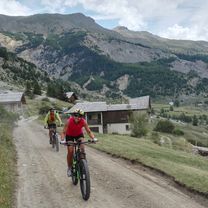
- Route des Grandes Alpes - Guillestre to Barcelonnette (10)
- Guillestre - Barcelonnette
- 54.3 km
- 1,261 m
- 1,041 m
- Guillestre, Provence-Alpes-C么te d'Azur Region, France
- 018 - 2014
- 77.7 km
- 1,637 m
- 2,039 m
- Guillestre, Provence-Alpes-C么te d'Azur Region, France
- Guillestre - Villar-Saint-Pancrace
- 41.9 km
- 1,587 m
- 1,398 m
- Guillestre, Provence-Alpes-C么te d'Azur Region, France
- Ambitieuse Ceillac ++
- 26.9 km
- 708 m
- 708 m
- Guillestre, Provence-Alpes-C么te d'Azur Region, France
- BIKESHOP-INT-GEB-Acc猫s Fouran
- 8.9 km
- 553 m
- 41 m
- Guillestre, Provence-Alpes-C么te d'Azur Region, France
- Guillestre - Brian莽on
- 23.9 km
- 1,410 m
- 1,131 m
- Guillestre, Provence-Alpes-C么te d'Azur Region, France
- Itin茅raire 脿 Guillestre
- 113.9 km
- 4,832 m
- 4,831 m
- Guillestre, Provence-Alpes-C么te d'Azur Region, France
Open it in the app


