
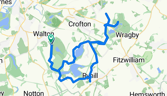
The Balk, Walton to Mill Lane 67, Ryhill
A cycling route starting in Walton, England, United Kingdom.
Overview
About this route
- 2 h 14 min
- Duration
- 24.1 km
- Distance
- 136 m
- Ascent
- 134 m
- Descent
- 10.8 km/h
- Avg. speed
- ---
- Max. altitude

Route photos


Continue with Bikemap
Use, edit, or download this cycling route
You would like to ride The Balk, Walton to Mill Lane 67, Ryhill or customize it for your own trip? Here is what you can do with this Bikemap route:
Free features
- Save this route as favorite or in collections
- Copy & plan your own version of this route
- Sync your route with Garmin or Wahoo
Premium features
Free trial for 3 days, or one-time payment. More about Bikemap Premium.
- Navigate this route on iOS & Android
- Export a GPX / KML file of this route
- Create your custom printout (try it for free)
- Download this route for offline navigation
Discover more Premium features.
Get Bikemap PremiumFrom our community
Other popular routes starting in Walton
 Sandal & Agbrigg to Wakefield
- Distance
- 17.7 km
- Ascent
- 367 m
- Descent
- 367 m
- Location
- Walton, England, United Kingdom
 Slow ride in Wakefield
- Distance
- 11.7 km
- Ascent
- 100 m
- Descent
- 66 m
- Location
- Walton, England, United Kingdom
 golf route
- Distance
- 7.1 km
- Ascent
- 87 m
- Descent
- 47 m
- Location
- Walton, England, United Kingdom
 Neil Fox Way, Wakefield to 13 Calder Row, Wakefield
- Distance
- 4 km
- Ascent
- 10 m
- Descent
- 16 m
- Location
- Walton, England, United Kingdom
 The Balk, Walton to Mill Lane 67, Ryhill
- Distance
- 24.1 km
- Ascent
- 136 m
- Descent
- 134 m
- Location
- Walton, England, United Kingdom
 Altofts and Normanton
- Distance
- 17.9 km
- Ascent
- 154 m
- Descent
- 158 m
- Location
- Walton, England, United Kingdom
 Walton Cycling
- Distance
- 35.8 km
- Ascent
- 189 m
- Descent
- 193 m
- Location
- Walton, England, United Kingdom
 Moderate route in Wakefield
- Distance
- 25.6 km
- Ascent
- 227 m
- Descent
- 290 m
- Location
- Walton, England, United Kingdom
Open it in the app