

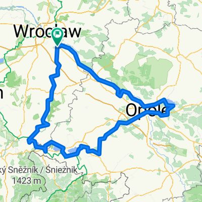
W koło Wrocławia
A cycling route starting in Święta Katarzyna, Lower Silesian Voivodeship, Poland.
Overview
About this route
- -:--
- Duration
- 55.9 km
- Distance
- 60 m
- Ascent
- 57 m
- Descent
- ---
- Avg. speed
- ---
- Max. altitude

Route quality
Waytypes & surfaces along the route
Waytypes
Path
18.4 km
(33 %)
Road
9.7 km
(17 %)
Surfaces
Paved
34.7 km
(62 %)
Unpaved
15.6 km
(28 %)
Asphalt
27.3 km
(49 %)
Gravel
12.8 km
(23 %)
Continue with Bikemap
Use, edit, or download this cycling route
You would like to ride W koło Wrocławia or customize it for your own trip? Here is what you can do with this Bikemap route:
Free features
- Save this route as favorite or in collections
- Copy & plan your own version of this route
- Sync your route with Garmin or Wahoo
Premium features
Free trial for 3 days, or one-time payment. More about Bikemap Premium.
- Navigate this route on iOS & Android
- Export a GPX / KML file of this route
- Create your custom printout (try it for free)
- Download this route for offline navigation
Discover more Premium features.
Get Bikemap PremiumFrom our community
Other popular routes starting in Święta Katarzyna
 Kaśka - Grodków
- Distance
- 51.1 km
- Ascent
- 87 m
- Descent
- 47 m
- Location
- Święta Katarzyna, Lower Silesian Voivodeship, Poland
 W koło Wrocławia
- Distance
- 83.4 km
- Ascent
- 56 m
- Descent
- 55 m
- Location
- Święta Katarzyna, Lower Silesian Voivodeship, Poland
 HH27 - św.katarzyna - mokry dwór - św.katrzyna
- Distance
- 26.9 km
- Ascent
- 12 m
- Descent
- 8 m
- Location
- Święta Katarzyna, Lower Silesian Voivodeship, Poland
 Pabianice
- Distance
- 228 km
- Ascent
- 275 m
- Descent
- 207 m
- Location
- Święta Katarzyna, Lower Silesian Voivodeship, Poland
 Józefa Bema 5, Święta Katarzyna to Spacerowa 102, Kotowice
- Distance
- 10.2 km
- Ascent
- 43 m
- Descent
- 46 m
- Location
- Święta Katarzyna, Lower Silesian Voivodeship, Poland
 Święta Katarzyna - Wrocław, Żmigrodzka
- Distance
- 32.4 km
- Ascent
- 31 m
- Descent
- 32 m
- Location
- Święta Katarzyna, Lower Silesian Voivodeship, Poland
 Wrocław - Kraków - Szczucin
- Distance
- 427.6 km
- Ascent
- 278 m
- Descent
- 235 m
- Location
- Święta Katarzyna, Lower Silesian Voivodeship, Poland
 Jesienny wypad
- Distance
- 340.5 km
- Ascent
- 370 m
- Descent
- 369 m
- Location
- Święta Katarzyna, Lower Silesian Voivodeship, Poland
Open it in the app