

Entlang der Schwäbischen Alb-Bahn 1. Teil Engstingen -> Münsingen
A cycling route starting in Unterhausen, Baden-Wurttemberg, Germany.
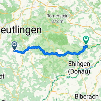
Overview
About this route
Starting point of this tour is Münsingen. Free parking spaces in the train station area are sufficiently available. You take the 'Ulmer-Spatz' (www.albbahn.de) to Engstingen. Taking bicycles in the special bike carriage is easily possible.
From Engstingen, you return along the Albbahn back to Münsingen.
The map material here is outdated. The entire bike tour takes place on paved paths. The only exception is a short stretch of about 1 km between Grafeneck and Fauserhöhe. There is gravel, well consolidated.
- -:--
- Duration
- 19.2 km
- Distance
- 224 m
- Ascent
- 210 m
- Descent
- ---
- Avg. speed
- ---
- Max. altitude

Route quality
Waytypes & surfaces along the route
Waytypes
Track
13.1 km
(68 %)
Quiet road
3.6 km
(19 %)
Surfaces
Paved
15.6 km
(81 %)
Unpaved
3.5 km
(18 %)
Asphalt
15.2 km
(79 %)
Unpaved (undefined)
1.9 km
(10 %)
Route highlights
Points of interest along the route
Point of interest after 6.9 km
Große Lauter Quelle
Point of interest after 7.2 km
Gestütsmuseum
Point of interest after 7.7 km
Aussichtsturm Sternberg
Point of interest after 9.6 km
Planeten Rundwanderweg
Point of interest after 9.9 km
Idyllischer Grillplatz mit klitzekleinem Seechen
Point of interest after 12.4 km
Landesgestüt Marbach
Point of interest after 13.9 km
Schloss Grafeneck
Point of interest after 14.4 km
KZ Gedenkstätte
Point of interest after 18.3 km
Alenbergbrunnen Rastpaltz
Continue with Bikemap
Use, edit, or download this cycling route
You would like to ride Entlang der Schwäbischen Alb-Bahn 1. Teil Engstingen -> Münsingen or customize it for your own trip? Here is what you can do with this Bikemap route:
Free features
- Save this route as favorite or in collections
- Copy & plan your own version of this route
- Sync your route with Garmin or Wahoo
Premium features
Free trial for 3 days, or one-time payment. More about Bikemap Premium.
- Navigate this route on iOS & Android
- Export a GPX / KML file of this route
- Create your custom printout (try it for free)
- Download this route for offline navigation
Discover more Premium features.
Get Bikemap PremiumFrom our community
Other popular routes starting in Unterhausen
 germany-swizz-france-spain
- Distance
- 2,110.7 km
- Ascent
- 6,122 m
- Descent
- 6,041 m
- Location
- Unterhausen, Baden-Wurttemberg, Germany
 2 Pt Lichtenstein to Semonzo to Rifugio Bassano
- Distance
- 585.8 km
- Ascent
- 4,422 m
- Descent
- 3,518 m
- Location
- Unterhausen, Baden-Wurttemberg, Germany
 Große Burladinger Runde
- Distance
- 97.8 km
- Ascent
- 1,132 m
- Descent
- 1,156 m
- Location
- Unterhausen, Baden-Wurttemberg, Germany
 Sonnenbühl - Blaubeuren
- Distance
- 62.7 km
- Ascent
- 220 m
- Descent
- 510 m
- Location
- Unterhausen, Baden-Wurttemberg, Germany
 Schöne Albtour
- Distance
- 46.4 km
- Ascent
- 563 m
- Descent
- 602 m
- Location
- Unterhausen, Baden-Wurttemberg, Germany
 Sonnenbühl-Trochtelfingen-Engstingen-Sonnenbühl
- Distance
- 44.3 km
- Ascent
- 366 m
- Descent
- 411 m
- Location
- Unterhausen, Baden-Wurttemberg, Germany
 über die Alb bis Donaueschingen
- Distance
- 97 km
- Ascent
- 1,073 m
- Descent
- 1,065 m
- Location
- Unterhausen, Baden-Wurttemberg, Germany
 Große Erbse
- Distance
- 78.3 km
- Ascent
- 766 m
- Descent
- 699 m
- Location
- Unterhausen, Baden-Wurttemberg, Germany
Open it in the app