

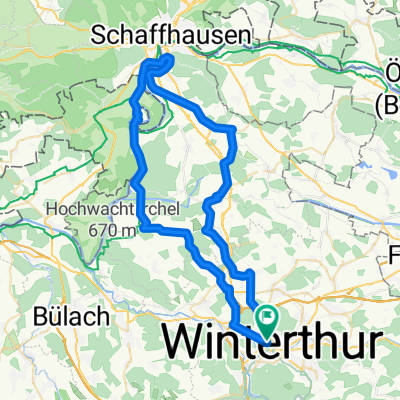
Wülflingerstrasse 3, Winterthur to Aeussere Zelglistrasse 19, Pfäffikon
A cycling route starting in Winterthur, Canton of Zurich, Switzerland.
Overview
About this route
- 1 h 9 min
- Duration
- 20.6 km
- Distance
- 246 m
- Ascent
- 131 m
- Descent
- 17.8 km/h
- Avg. speed
- ---
- Max. altitude

Route quality
Waytypes & surfaces along the route
Waytypes
Path
7.6 km
(37 %)
Pedestrian area
3.5 km
(17 %)
Surfaces
Paved
17.3 km
(84 %)
Unpaved
2.7 km
(13 %)
Asphalt
16.5 km
(80 %)
Gravel
2.3 km
(11 %)
Continue with Bikemap
Use, edit, or download this cycling route
You would like to ride Wülflingerstrasse 3, Winterthur to Aeussere Zelglistrasse 19, Pfäffikon or customize it for your own trip? Here is what you can do with this Bikemap route:
Free features
- Save this route as favorite or in collections
- Copy & plan your own version of this route
- Sync your route with Garmin or Wahoo
Premium features
Free trial for 3 days, or one-time payment. More about Bikemap Premium.
- Navigate this route on iOS & Android
- Export a GPX / KML file of this route
- Create your custom printout (try it for free)
- Download this route for offline navigation
Discover more Premium features.
Get Bikemap PremiumFrom our community
Other popular routes starting in Winterthur
 Rheinau-Rheinfall
- Distance
- 59.1 km
- Ascent
- 427 m
- Descent
- 427 m
- Location
- Winterthur, Canton of Zurich, Switzerland
 Winterthur - Mülligen
- Distance
- 76.4 km
- Ascent
- 290 m
- Descent
- 371 m
- Location
- Winterthur, Canton of Zurich, Switzerland
 Bachtelstrasse 5, Winterthur nach Bachtelstrasse 25, Winterthur
- Distance
- 22.2 km
- Ascent
- 278 m
- Descent
- 285 m
- Location
- Winterthur, Canton of Zurich, Switzerland
 Wülflingerstrasse 3, Winterthur to Aeussere Zelglistrasse 19, Pfäffikon
- Distance
- 20.6 km
- Ascent
- 246 m
- Descent
- 131 m
- Location
- Winterthur, Canton of Zurich, Switzerland
 Tödistrasse 4–6, Winterthur nach Allmeindstrasse 16, Schmerikon
- Distance
- 55.1 km
- Ascent
- 4,106 m
- Descent
- 4,135 m
- Location
- Winterthur, Canton of Zurich, Switzerland
 Schützenstrasse 81, Winterthur nach Bachtelstrasse 23, Winterthur
- Distance
- 21 km
- Ascent
- 233 m
- Descent
- 250 m
- Location
- Winterthur, Canton of Zurich, Switzerland
 Schützenstrasse 81, Winterthur nach Schützenstrasse 81, Winterthur
- Distance
- 14.6 km
- Ascent
- 65 m
- Descent
- 77 m
- Location
- Winterthur, Canton of Zurich, Switzerland
 Bachtelstrasse 15–19, Winterthur nach Tösswisweg, Wildberg
- Distance
- 16.4 km
- Ascent
- 205 m
- Descent
- 104 m
- Location
- Winterthur, Canton of Zurich, Switzerland
Open it in the app