

Slovenského národného povstania 2, Žiar nad Hronom do J. Hollého 5
A cycling route starting in Žiar nad Hronom, Banská Bystrica Region, Slovakia.
Overview
About this route
- 5 h 57 min
- Duration
- 48.7 km
- Distance
- 1,050 m
- Ascent
- 1,007 m
- Descent
- 8.2 km/h
- Avg. speed
- ---
- Max. altitude

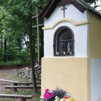
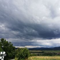
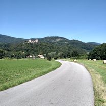
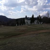
Route photos


Continue with Bikemap
Use, edit, or download this cycling route
You would like to ride Slovenského národného povstania 2, Žiar nad Hronom do J. Hollého 5 or customize it for your own trip? Here is what you can do with this Bikemap route:
Free features
- Save this route as favorite or in collections
- Copy & plan your own version of this route
- Sync your route with Garmin or Wahoo
Premium features
Free trial for 3 days, or one-time payment. More about Bikemap Premium.
- Navigate this route on iOS & Android
- Export a GPX / KML file of this route
- Create your custom printout (try it for free)
- Download this route for offline navigation
Discover more Premium features.
Get Bikemap PremiumFrom our community
Other popular routes starting in Žiar nad Hronom
 Lutila-Ihráč-Hostinec-Kremnica-Lutila
- Distance
- 61.7 km
- Ascent
- 1,027 m
- Descent
- 1,027 m
- Location
- Žiar nad Hronom, Banská Bystrica Region, Slovakia
 Vtačnik, Biela skala,
- Distance
- 64 km
- Ascent
- 1,562 m
- Descent
- 1,551 m
- Location
- Žiar nad Hronom, Banská Bystrica Region, Slovakia
 ZH, Slaska, J. Lehota, ZH
- Distance
- 22.8 km
- Ascent
- 326 m
- Descent
- 311 m
- Location
- Žiar nad Hronom, Banská Bystrica Region, Slovakia
 ZH - Podhorie - Hr. Dúbrava - ZH
- Distance
- 77.1 km
- Ascent
- 697 m
- Descent
- 697 m
- Location
- Žiar nad Hronom, Banská Bystrica Region, Slovakia
 PWG ~pohovor👍🚴👍31.7.²0²0
- Distance
- 47.8 km
- Ascent
- 299 m
- Descent
- 293 m
- Location
- Žiar nad Hronom, Banská Bystrica Region, Slovakia
 Lutila-Kunešov-Kopernica-Lutila
- Distance
- 37.7 km
- Ascent
- 685 m
- Descent
- 685 m
- Location
- Žiar nad Hronom, Banská Bystrica Region, Slovakia
 ZH, Šibeničny vrch, ST. Kremnička, ZH
- Distance
- 16.5 km
- Ascent
- 234 m
- Descent
- 234 m
- Location
- Žiar nad Hronom, Banská Bystrica Region, Slovakia
 Slovenského národného povstania 2, Žiar nad Hronom do J. Hollého 5
- Distance
- 48.7 km
- Ascent
- 1,050 m
- Descent
- 1,007 m
- Location
- Žiar nad Hronom, Banská Bystrica Region, Slovakia
Open it in the app