
USBR 76 KY
A cycling route starting in Elizabethtown, Illinois, United States of America.
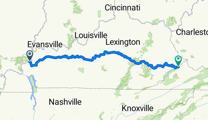
Overview
About this route
Statistics computed from imported data
Distance: 484.0 miles Minimum Elevation: 329 feet Maximum Elevation: 1813 feet Total climb: 24426 feet Total descent: 23740 feet
- -:--
- Duration
- 716.4 km
- Distance
- 9,738 m
- Ascent
- 9,511 m
- Descent
- ---
- Avg. speed
- ---
- Max. altitude

Route quality
Waytypes & surfaces along the route
Waytypes
Busy road
642 km
(90 %)
Road
45.1 km
(6 %)
Surfaces
Paved
87.1 km
(12 %)
Paved (undefined)
61.5 km
(9 %)
Asphalt
25.5 km
(4 %)
Continue with Bikemap
Use, edit, or download this cycling route
You would like to ride USBR 76 KY or customize it for your own trip? Here is what you can do with this Bikemap route:
Free features
- Save this route as favorite or in collections
- Copy & plan your own version of this route
- Split it into stages to create a multi-day tour
- Sync your route with Garmin or Wahoo
Premium features
Free trial for 3 days, or one-time payment. More about Bikemap Premium.
- Navigate this route on iOS & Android
- Export a GPX / KML file of this route
- Create your custom printout (try it for free)
- Download this route for offline navigation
Discover more Premium features.
Get Bikemap PremiumFrom our community
Other popular routes starting in Elizabethtown
 76: Elizabethtown to Clay
- Distance
- 46 km
- Ascent
- 453 m
- Descent
- 422 m
- Location
- Elizabethtown, Illinois, United States of America
 Illinois
- Distance
- 343.5 km
- Ascent
- 618 m
- Descent
- 598 m
- Location
- Elizabethtown, Illinois, United States of America
 101–133 E First St, Elizabethtown to 1750 KY-132, Marion
- Distance
- 59.1 km
- Ascent
- 591 m
- Descent
- 580 m
- Location
- Elizabethtown, Illinois, United States of America
 Cave-in-Rock-Joplin
- Distance
- 759.1 km
- Ascent
- 1,084 m
- Descent
- 891 m
- Location
- Elizabethtown, Illinois, United States of America
 Cave In Rocks, IL. to Yellowstone National Park
- Distance
- 2,876.1 km
- Ascent
- 12,336 m
- Descent
- 10,053 m
- Location
- Elizabethtown, Illinois, United States of America
 28/100
- Distance
- 83.6 km
- Ascent
- 1,064 m
- Descent
- 970 m
- Location
- Elizabethtown, Illinois, United States of America
 Cave-In-Rock to North Broadway 319, Pittsburg
- Distance
- 764.2 km
- Ascent
- 5,644 m
- Descent
- 5,470 m
- Location
- Elizabethtown, Illinois, United States of America
 Cave-In-Rock to United States, Portland
- Distance
- 4,419.9 km
- Ascent
- 5,998 m
- Descent
- 6,089 m
- Location
- Elizabethtown, Illinois, United States of America
Open it in the app