

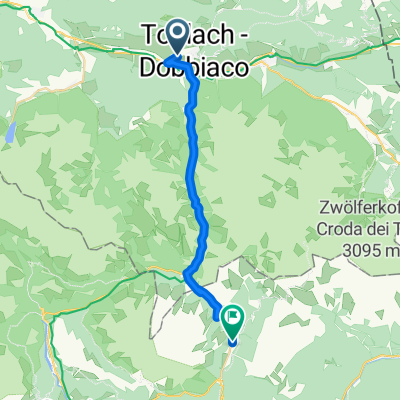
TRE CIME DI LAVAREDO- REFUGIO AURONZO (por Dobbiaco/Toblach)
A cycling route starting in Toblach, Trentino-Alto Adige, Italy.
Overview
About this route
- -:--
- Duration
- 26.6 km
- Distance
- 1,130 m
- Ascent
- 49 m
- Descent
- ---
- Avg. speed
- ---
- Max. altitude

Route quality
Waytypes & surfaces along the route
Waytypes
Cycleway
10.9 km
(41 %)
Quiet road
7.7 km
(29 %)
Surfaces
Paved
14.4 km
(54 %)
Unpaved
12.3 km
(46 %)
Asphalt
14.4 km
(54 %)
Gravel
8 km
(30 %)
Continue with Bikemap
Use, edit, or download this cycling route
You would like to ride TRE CIME DI LAVAREDO- REFUGIO AURONZO (por Dobbiaco/Toblach) or customize it for your own trip? Here is what you can do with this Bikemap route:
Free features
- Save this route as favorite or in collections
- Copy & plan your own version of this route
- Sync your route with Garmin or Wahoo
Premium features
Free trial for 3 days, or one-time payment. More about Bikemap Premium.
- Navigate this route on iOS & Android
- Export a GPX / KML file of this route
- Create your custom printout (try it for free)
- Download this route for offline navigation
Discover more Premium features.
Get Bikemap PremiumFrom our community
Other popular routes starting in Toblach
 Drauradweg Toblach - Lienz
- Distance
- 45.9 km
- Ascent
- 475 m
- Descent
- 1,011 m
- Location
- Toblach, Trentino-Alto Adige, Italy
 Od Lago di Landro přes Bruneck do Nauders
- Distance
- 71.4 km
- Ascent
- 422 m
- Descent
- 828 m
- Location
- Toblach, Trentino-Alto Adige, Italy
 Toblach - Olang - Bruneck - Toblach
- Distance
- 68.4 km
- Ascent
- 606 m
- Descent
- 655 m
- Location
- Toblach, Trentino-Alto Adige, Italy
 Markinkele
- Distance
- 51.1 km
- Ascent
- 1,443 m
- Descent
- 1,443 m
- Location
- Toblach, Trentino-Alto Adige, Italy
 Un Passo dal Cielo Agosto 2021-Dobbiaco, lago di Braies
- Distance
- 15.7 km
- Ascent
- 502 m
- Descent
- 200 m
- Location
- Toblach, Trentino-Alto Adige, Italy
 Dobbiaco - Calalzo di Cadore
- Distance
- 63 km
- Ascent
- 325 m
- Descent
- 851 m
- Location
- Toblach, Trentino-Alto Adige, Italy
 From Dobbiaco to Misurina Lake
- Distance
- 21.2 km
- Ascent
- 591 m
- Descent
- 63 m
- Location
- Toblach, Trentino-Alto Adige, Italy
 Toblach to Brixen - etappe 1 tdf 2025
- Distance
- 75 km
- Ascent
- 1,408 m
- Descent
- 2,062 m
- Location
- Toblach, Trentino-Alto Adige, Italy
Open it in the app