

Giro Chryszczata
A cycling route starting in Rzepedź, Subcarpathian Voivodeship, Poland.
Overview
About this route
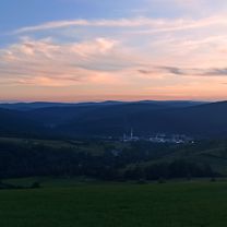
The route is varied and moderately difficult. In the first stage, it gently ascends from Rzepedź up the Osława valley, crossing numerous fords (6). From Mików, a long, arduous climb begins to the Żebrak Pass (816 m above sea level). Then follows a spectacular, several-kilometer descent into the Rabe valley. The ride continues on gravel paths to Bystre. Then a turnaround and return via Huczwice and the Bobrowe lake. Before Kalnica, turn left for a climb to the pass below Suliła and the last long descent back to Rzepedź, passing on the right side the wooden architectural monument listed by UNESCO – the Orthodox Church of St. Michael the Archangel in Turzańsk from 1803.
- -:--
- Duration
- 47.9 km
- Distance
- 801 m
- Ascent
- 804 m
- Descent
- ---
- Avg. speed
- ---
- Max. altitude

Route quality
Waytypes & surfaces along the route
Waytypes
Quiet road
21.1 km
(44 %)
Track
19.6 km
(41 %)
Surfaces
Paved
37.8 km
(79 %)
Unpaved
1.9 km
(4 %)
Asphalt
25.8 km
(54 %)
Paved (undefined)
9.6 km
(20 %)
Continue with Bikemap
Use, edit, or download this cycling route
You would like to ride Giro Chryszczata or customize it for your own trip? Here is what you can do with this Bikemap route:
Free features
- Save this route as favorite or in collections
- Copy & plan your own version of this route
- Sync your route with Garmin or Wahoo
Premium features
Free trial for 3 days, or one-time payment. More about Bikemap Premium.
- Navigate this route on iOS & Android
- Export a GPX / KML file of this route
- Create your custom printout (try it for free)
- Download this route for offline navigation
Discover more Premium features.
Get Bikemap PremiumFrom our community
Other popular routes starting in Rzepedź
 Turzańsk do Rzepedź przez Suliłe
- Distance
- 10.6 km
- Ascent
- 332 m
- Descent
- 346 m
- Location
- Rzepedź, Subcarpathian Voivodeship, Poland
 Pętla Rzepedź Kalnica Rzepedź
- Distance
- 51.5 km
- Ascent
- 813 m
- Descent
- 811 m
- Location
- Rzepedź, Subcarpathian Voivodeship, Poland
 Giro Chryszczata
- Distance
- 47.9 km
- Ascent
- 801 m
- Descent
- 804 m
- Location
- Rzepedź, Subcarpathian Voivodeship, Poland
 Rzepedź do Rzepedź
- Distance
- 41.8 km
- Ascent
- 1,074 m
- Descent
- 1,074 m
- Location
- Rzepedź, Subcarpathian Voivodeship, Poland
 Rzepedź - Sanok przez Daliową
- Distance
- 97 km
- Ascent
- 660 m
- Descent
- 806 m
- Location
- Rzepedź, Subcarpathian Voivodeship, Poland
 CYKLOTÚRA ŽEBRAK TURZANSK -2
- Distance
- 41.5 km
- Ascent
- 740 m
- Descent
- 743 m
- Location
- Rzepedź, Subcarpathian Voivodeship, Poland
 Rzepedź - Baligród - Rzepedź
- Distance
- 61.1 km
- Ascent
- 745 m
- Descent
- 742 m
- Location
- Rzepedź, Subcarpathian Voivodeship, Poland
 Rzepedź - Komańcza - Jawornik
- Distance
- 33 km
- Ascent
- 335 m
- Descent
- 335 m
- Location
- Rzepedź, Subcarpathian Voivodeship, Poland
Open it in the app