

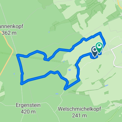
Lohrheim-Mensfelderkopf-Niederneisen-Lohrheim
A cycling route starting in Lohrheim, Rhineland-Palatinate, Germany.
Overview
About this route
- 1 h 6 min
- Duration
- 13.9 km
- Distance
- 266 m
- Ascent
- 265 m
- Descent
- 12.6 km/h
- Avg. speed
- ---
- Max. altitude
Route quality
Waytypes & surfaces along the route
Waytypes
Track
6.7 km
(48 %)
Quiet road
3.1 km
(22 %)
Surfaces
Paved
11.8 km
(85 %)
Unpaved
1.5 km
(11 %)
Asphalt
11.8 km
(85 %)
Ground
1 km
(7 %)
Continue with Bikemap
Use, edit, or download this cycling route
You would like to ride Lohrheim-Mensfelderkopf-Niederneisen-Lohrheim or customize it for your own trip? Here is what you can do with this Bikemap route:
Free features
- Save this route as favorite or in collections
- Copy & plan your own version of this route
- Sync your route with Garmin or Wahoo
Premium features
Free trial for 3 days, or one-time payment. More about Bikemap Premium.
- Navigate this route on iOS & Android
- Export a GPX / KML file of this route
- Create your custom printout (try it for free)
- Download this route for offline navigation
Discover more Premium features.
Get Bikemap PremiumFrom our community
Other popular routes starting in Lohrheim
 Bachstraße 42, Lohrheim nach Bachstraße 19, Lohrheim
- Distance
- 18.3 km
- Ascent
- 527 m
- Descent
- 535 m
- Location
- Lohrheim, Rhineland-Palatinate, Germany
 ?ٜ?? nach ?ٜ??
- Distance
- 25.7 km
- Ascent
- 413 m
- Descent
- 412 m
- Location
- Lohrheim, Rhineland-Palatinate, Germany
 Bachstraße 44, Lohrheim nach Diezer Straße 5, Birlenbach
- Distance
- 9 km
- Ascent
- 233 m
- Descent
- 306 m
- Location
- Lohrheim, Rhineland-Palatinate, Germany
 Auf der Bleiche, Lohrheim nach Rheingauer Straße, Lohrheim
- Distance
- 9.7 km
- Ascent
- 245 m
- Descent
- 242 m
- Location
- Lohrheim, Rhineland-Palatinate, Germany
 Bachstraße 42, Lohrheim nach Aarstraße, Katzenelnbogen
- Distance
- 8.9 km
- Ascent
- 238 m
- Descent
- 138 m
- Location
- Lohrheim, Rhineland-Palatinate, Germany
 Lohrheim-Mensfelderkopf-Niederneisen-Lohrheim
- Distance
- 13.9 km
- Ascent
- 266 m
- Descent
- 265 m
- Location
- Lohrheim, Rhineland-Palatinate, Germany
 An der Mehrzweckhalle 11, Lohrheim nach Schaumburger Straße 13, Lohrheim
- Distance
- 6.1 km
- Ascent
- 160 m
- Descent
- 163 m
- Location
- Lohrheim, Rhineland-Palatinate, Germany
Open it in the app