

Frankenwald
A cycling route starting in Schauenstein, Bavaria, Germany.
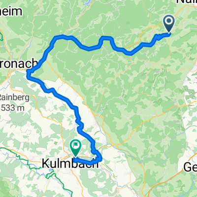
Overview
About this route
very steep climbs, deep forests
- -:--
- Duration
- 20.8 km
- Distance
- 320 m
- Ascent
- 321 m
- Descent
- ---
- Avg. speed
- ---
- Max. altitude

Route quality
Waytypes & surfaces along the route
Waytypes
Track
8.5 km
(41 %)
Quiet road
7.5 km
(36 %)
Surfaces
Paved
5.6 km
(27 %)
Unpaved
6.7 km
(32 %)
Asphalt
5.4 km
(26 %)
Ground
5.2 km
(25 %)
Continue with Bikemap
Use, edit, or download this cycling route
You would like to ride Frankenwald or customize it for your own trip? Here is what you can do with this Bikemap route:
Free features
- Save this route as favorite or in collections
- Copy & plan your own version of this route
- Sync your route with Garmin or Wahoo
Premium features
Free trial for 3 days, or one-time payment. More about Bikemap Premium.
- Navigate this route on iOS & Android
- Export a GPX / KML file of this route
- Create your custom printout (try it for free)
- Download this route for offline navigation
Discover more Premium features.
Get Bikemap PremiumFrom our community
Other popular routes starting in Schauenstein
 Dr.-Martin-Luther-Platz 3, Schauenstein nach Marktplatz 13, Schauenstein
- Distance
- 39.4 km
- Ascent
- 1,085 m
- Descent
- 1,087 m
- Location
- Schauenstein, Bavaria, Germany
 Rund um den Döbraberg
- Distance
- 16.7 km
- Ascent
- 441 m
- Descent
- 441 m
- Location
- Schauenstein, Bavaria, Germany
 Doebra_Vogtendorf_KU
- Distance
- 60 km
- Ascent
- 587 m
- Descent
- 975 m
- Location
- Schauenstein, Bavaria, Germany
 Trainingsrunde 25km Almbranz-Hof
- Distance
- 24.1 km
- Ascent
- 205 m
- Descent
- 319 m
- Location
- Schauenstein, Bavaria, Germany
 von Schauenstein zum Untreusee
- Distance
- 34.5 km
- Ascent
- 361 m
- Descent
- 361 m
- Location
- Schauenstein, Bavaria, Germany
 KU über Steinachklamm und Rehberg über Plassenburg
- Distance
- 49.9 km
- Ascent
- 330 m
- Descent
- 619 m
- Location
- Schauenstein, Bavaria, Germany
 Deel2
Deel2- Distance
- 29.5 km
- Ascent
- 417 m
- Descent
- 418 m
- Location
- Schauenstein, Bavaria, Germany
 Frankenwald
- Distance
- 20.8 km
- Ascent
- 320 m
- Descent
- 321 m
- Location
- Schauenstein, Bavaria, Germany
Open it in the app