

gemütliche
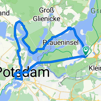
A cycling route starting in Wannsee, State of Berlin, Germany.
Overview
About this route
- 55 min
- Duration
- 11.3 km
- Distance
- 163 m
- Ascent
- 163 m
- Descent
- 12.5 km/h
- Avg. speed
- ---
- Max. altitude
Continue with Bikemap
Use, edit, or download this cycling route
You would like to ride gemütliche or customize it for your own trip? Here is what you can do with this Bikemap route:
Free features
- Save this route as favorite or in collections
- Copy & plan your own version of this route
- Sync your route with Garmin or Wahoo
Premium features
Free trial for 3 days, or one-time payment. More about Bikemap Premium.
- Navigate this route on iOS & Android
- Export a GPX / KML file of this route
- Create your custom printout (try it for free)
- Download this route for offline navigation
Discover more Premium features.
Get Bikemap PremiumFrom our community
Other popular routes starting in Wannsee
 Kleinmanchow und der Abstecher in den Grunewald Teil 1
- Distance
- 12.8 km
- Ascent
- 610 m
- Descent
- 745 m
- Location
- Wannsee, State of Berlin, Germany
 Berlin Wannsee- Brandenburg
- Distance
- 49.3 km
- Ascent
- 119 m
- Descent
- 131 m
- Location
- Wannsee, State of Berlin, Germany
 Rudolf-Breitscheid-Straße, Potsdam nach Babelsberger Straße, Potsdam
- Distance
- 19.1 km
- Ascent
- 110 m
- Descent
- 105 m
- Location
- Wannsee, State of Berlin, Germany
 50 km Giro di Wannsee
- Distance
- 47 km
- Ascent
- 270 m
- Descent
- 270 m
- Location
- Wannsee, State of Berlin, Germany
 50 km Wannsee Runde
- Distance
- 36.4 km
- Ascent
- 232 m
- Descent
- 234 m
- Location
- Wannsee, State of Berlin, Germany
 Wannsee-Runde
- Distance
- 17.3 km
- Ascent
- 126 m
- Descent
- 128 m
- Location
- Wannsee, State of Berlin, Germany
 Steglitz-Zehlendorf, Berlin nach Steglitz-Zehlendorf, Berlin
- Distance
- 2.7 km
- Ascent
- 86 m
- Descent
- 97 m
- Location
- Wannsee, State of Berlin, Germany
 Wannseerunde
- Distance
- 20.6 km
- Ascent
- 119 m
- Descent
- 124 m
- Location
- Wannsee, State of Berlin, Germany
Open it in the app