

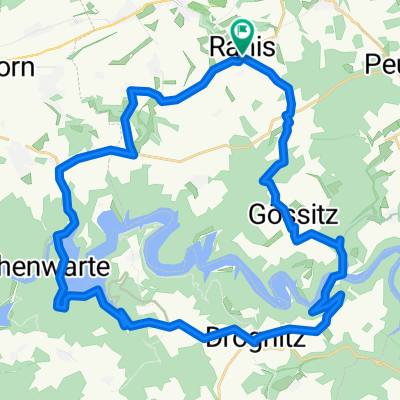
Ranis-Saalfeld-Ranis
A cycling route starting in Ranis, Free State of Thuringia, Germany.
Overview
About this route
Schöne Rundtour mit gutem Blick vom Roten Berg zurück auf Saalfeld und vorher auf angenehmen Radwegen oder wenig befahrenen Straßen nach Saalfeld.
- -:--
- Duration
- 34.4 km
- Distance
- 380 m
- Ascent
- 366 m
- Descent
- ---
- Avg. speed
- ---
- Max. altitude

Route quality
Waytypes & surfaces along the route
Waytypes
Quiet road
19.3 km
(56 %)
Road
10.4 km
(30 %)
Surfaces
Paved
12.8 km
(37 %)
Unpaved
1.4 km
(4 %)
Asphalt
12.8 km
(37 %)
Gravel
1.4 km
(4 %)
Undefined
20.3 km
(59 %)
Continue with Bikemap
Use, edit, or download this cycling route
You would like to ride Ranis-Saalfeld-Ranis or customize it for your own trip? Here is what you can do with this Bikemap route:
Free features
- Save this route as favorite or in collections
- Copy & plan your own version of this route
- Sync your route with Garmin or Wahoo
Premium features
Free trial for 3 days, or one-time payment. More about Bikemap Premium.
- Navigate this route on iOS & Android
- Export a GPX / KML file of this route
- Create your custom printout (try it for free)
- Download this route for offline navigation
Discover more Premium features.
Get Bikemap PremiumFrom our community
Other popular routes starting in Ranis
 Ranis-Saalfeld-Ranis
- Distance
- 34.4 km
- Ascent
- 380 m
- Descent
- 366 m
- Location
- Ranis, Free State of Thuringia, Germany
 L2367 2, Ranis nach L2367 2, Ranis
- Distance
- 37.2 km
- Ascent
- 1,596 m
- Descent
- 1,596 m
- Location
- Ranis, Free State of Thuringia, Germany
 Bahnhofstraße 17, Ranis nach Am Stauseeblick 1, Hohenwarte
- Distance
- 10 km
- Ascent
- 357 m
- Descent
- 325 m
- Location
- Ranis, Free State of Thuringia, Germany
 Planstraße 11, Ranis nach Mittelweg, Pößneck
- Distance
- 9.3 km
- Ascent
- 41 m
- Descent
- 197 m
- Location
- Ranis, Free State of Thuringia, Germany
 Route von Blumenstraße 41, Ranis
- Distance
- 41.9 km
- Ascent
- 419 m
- Descent
- 455 m
- Location
- Ranis, Free State of Thuringia, Germany
 Blumenstraße 41, Ranis nach Planstraße 13, Ranis
- Distance
- 16.9 km
- Ascent
- 633 m
- Descent
- 634 m
- Location
- Ranis, Free State of Thuringia, Germany
 Rathausstraße 6, Ranis nach Friedebacher Straße 45, Krölpa
- Distance
- 5.2 km
- Ascent
- 78 m
- Descent
- 181 m
- Location
- Ranis, Free State of Thuringia, Germany
 Am Burgparkplatz 2, Ranis nach Brandenstein 1, Ranis
- Distance
- 1.2 km
- Ascent
- 37 m
- Descent
- 74 m
- Location
- Ranis, Free State of Thuringia, Germany
Open it in the app