

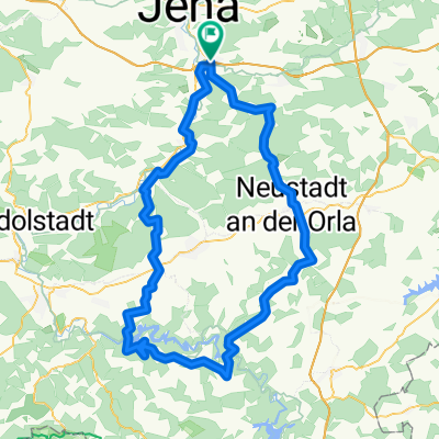
Jena Umland
A cycling route starting in Sulza, Thuringia, Germany.
Overview
About this route
- 3 h 42 min
- Duration
- 60.7 km
- Distance
- 449 m
- Ascent
- 459 m
- Descent
- 16.4 km/h
- Avg. speed
- ---
- Max. altitude

Route photos


Route quality
Waytypes & surfaces along the route
Waytypes
Track
21.9 km
(36 %)
Quiet road
12.1 km
(20 %)
Surfaces
Paved
40.7 km
(67 %)
Unpaved
16.4 km
(27 %)
Asphalt
40.1 km
(66 %)
Gravel
12.8 km
(21 %)
Continue with Bikemap
Use, edit, or download this cycling route
You would like to ride Jena Umland or customize it for your own trip? Here is what you can do with this Bikemap route:
Free features
- Save this route as favorite or in collections
- Copy & plan your own version of this route
- Sync your route with Garmin or Wahoo
Premium features
Free trial for 3 days, or one-time payment. More about Bikemap Premium.
- Navigate this route on iOS & Android
- Export a GPX / KML file of this route
- Create your custom printout (try it for free)
- Download this route for offline navigation
Discover more Premium features.
Get Bikemap PremiumFrom our community
Other popular routes starting in Sulza
 Leuchtenburg Hintenherum
- Distance
- 36.5 km
- Ascent
- 342 m
- Descent
- 342 m
- Location
- Sulza, Thuringia, Germany
 Jena - Altenburg
- Distance
- 140.6 km
- Ascent
- 1,090 m
- Descent
- 1,010 m
- Location
- Sulza, Thuringia, Germany
 Saale-Holzland-Tour
- Distance
- 61.1 km
- Ascent
- 518 m
- Descent
- 564 m
- Location
- Sulza, Thuringia, Germany
 Einfache Fahrt in Schöps
- Distance
- 5.1 km
- Ascent
- 53 m
- Descent
- 50 m
- Location
- Sulza, Thuringia, Germany
 Talsperrenrunde kurz
- Distance
- 113.3 km
- Ascent
- 1,117 m
- Descent
- 1,117 m
- Location
- Sulza, Thuringia, Germany
 MTB Waldwege
- Distance
- 21.5 km
- Ascent
- 470 m
- Descent
- 480 m
- Location
- Sulza, Thuringia, Germany
 Westschleife
- Distance
- 57.5 km
- Ascent
- 419 m
- Descent
- 418 m
- Location
- Sulza, Thuringia, Germany
 Kulturtour mit Fernblick
- Distance
- 51.9 km
- Ascent
- 388 m
- Descent
- 388 m
- Location
- Sulza, Thuringia, Germany
Open it in the app