

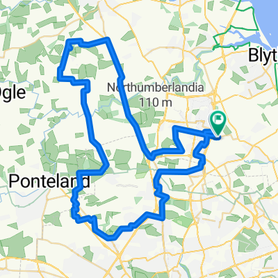
Steady ride in Cramlington
A cycling route starting in Cramlington, England, United Kingdom.
Overview
About this route
- 1 h 34 min
- Duration
- 29.7 km
- Distance
- 8 m
- Ascent
- 0 m
- Descent
- 19 km/h
- Avg. speed
- ---
- Max. altitude
Route quality
Waytypes & surfaces along the route
Waytypes
Cycleway
9.2 km
(31 %)
Road
7.1 km
(24 %)
Surfaces
Paved
4.2 km
(14 %)
Unpaved
1.5 km
(5 %)
Asphalt
4.2 km
(14 %)
Gravel
1.2 km
(4 %)
Continue with Bikemap
Use, edit, or download this cycling route
You would like to ride Steady ride in Cramlington or customize it for your own trip? Here is what you can do with this Bikemap route:
Free features
- Save this route as favorite or in collections
- Copy & plan your own version of this route
- Sync your route with Garmin or Wahoo
Premium features
Free trial for 3 days, or one-time payment. More about Bikemap Premium.
- Navigate this route on iOS & Android
- Export a GPX / KML file of this route
- Create your custom printout (try it for free)
- Download this route for offline navigation
Discover more Premium features.
Get Bikemap PremiumFrom our community
Other popular routes starting in Cramlington
 Avebury Place 26 to Avebury Place 4
- Distance
- 16 km
- Ascent
- 58 m
- Descent
- 63 m
- Location
- Cramlington, England, United Kingdom
 Bay horse to Tynemouth
- Distance
- 34.9 km
- Ascent
- 191 m
- Descent
- 193 m
- Location
- Cramlington, England, United Kingdom
 Rouen Crescent to Rouen Crescent
- Distance
- 58.9 km
- Ascent
- 263 m
- Descent
- 262 m
- Location
- Cramlington, England, United Kingdom
 cramlington seghill seaton sluice seaton delaval cramlington
- Distance
- 15.8 km
- Ascent
- 239 m
- Descent
- 237 m
- Location
- Cramlington, England, United Kingdom
 Bog Houses, Cramlington to Kew Gardens, Whitley Bay
- Distance
- 63.4 km
- Ascent
- 298 m
- Descent
- 318 m
- Location
- Cramlington, England, United Kingdom
 Quick 28m
- Distance
- 46.9 km
- Ascent
- 136 m
- Descent
- 137 m
- Location
- Cramlington, England, United Kingdom
 Cobalt Route
- Distance
- 9.9 km
- Ascent
- 40 m
- Descent
- 26 m
- Location
- Cramlington, England, United Kingdom
 High-speed route in Cramlington
- Distance
- 58.2 km
- Ascent
- 9 m
- Descent
- 11 m
- Location
- Cramlington, England, United Kingdom
Open it in the app