

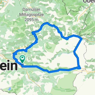
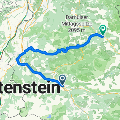
Gemütliche Route in Bludenz
A cycling route starting in Bludenz, Vorarlberg, Austria.
Overview
About this route
- 2 h 37 min
- Duration
- 37.5 km
- Distance
- 1,035 m
- Ascent
- 1,035 m
- Descent
- 14.3 km/h
- Avg. speed
- ---
- Max. altitude

Continue with Bikemap
Use, edit, or download this cycling route
You would like to ride Gemütliche Route in Bludenz or customize it for your own trip? Here is what you can do with this Bikemap route:
Free features
- Save this route as favorite or in collections
- Copy & plan your own version of this route
- Sync your route with Garmin or Wahoo
Premium features
Free trial for 3 days, or one-time payment. More about Bikemap Premium.
- Navigate this route on iOS & Android
- Export a GPX / KML file of this route
- Create your custom printout (try it for free)
- Download this route for offline navigation
Discover more Premium features.
Get Bikemap PremiumFrom our community
Other popular routes starting in Bludenz
 Alpen Challenge 2015 - Brandnertal
- Distance
- 61.5 km
- Ascent
- 1,942 m
- Descent
- 1,941 m
- Location
- Bludenz, Vorarlberg, Austria
 Obdorfweg 39b nach Stuben 1356/2
- Distance
- 30.7 km
- Ascent
- 1,042 m
- Descent
- 352 m
- Location
- Bludenz, Vorarlberg, Austria
 Tag 3: Bludenz - Faschina - Flexenpass - Bludenz
- Distance
- 111.9 km
- Ascent
- 2,385 m
- Descent
- 2,385 m
- Location
- Bludenz, Vorarlberg, Austria
 Alpencross 2008 - Etappe 2
- Distance
- 41.1 km
- Ascent
- 1,738 m
- Descent
- 1,114 m
- Location
- Bludenz, Vorarlberg, Austria
 Von Bluzenz zur Schneekopfbahn
- Distance
- 21.4 km
- Ascent
- 601 m
- Descent
- 182 m
- Location
- Bludenz, Vorarlberg, Austria
 Via Volker
- Distance
- 286.6 km
- Ascent
- 2,408 m
- Descent
- 2,430 m
- Location
- Bludenz, Vorarlberg, Austria
 Bludenz-Schoppernau
- Distance
- 71.2 km
- Ascent
- 2,397 m
- Descent
- 2,119 m
- Location
- Bludenz, Vorarlberg, Austria
 2019-07, Vorarlberg-Tour
- Distance
- 111.6 km
- Ascent
- 2,181 m
- Descent
- 2,182 m
- Location
- Bludenz, Vorarlberg, Austria
Open it in the app