

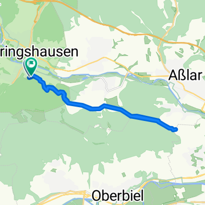
Ehringshausen Tiefenbach
A cycling route starting in Ehringshausen, Hesse, Germany.
Overview
About this route
The route is a nice stretch for beginners.
- -:--
- Duration
- 19 km
- Distance
- 411 m
- Ascent
- 408 m
- Descent
- ---
- Avg. speed
- ---
- Max. altitude

Continue with Bikemap
Use, edit, or download this cycling route
You would like to ride Ehringshausen Tiefenbach or customize it for your own trip? Here is what you can do with this Bikemap route:
Free features
- Save this route as favorite or in collections
- Copy & plan your own version of this route
- Sync your route with Garmin or Wahoo
Premium features
Free trial for 3 days, or one-time payment. More about Bikemap Premium.
- Navigate this route on iOS & Android
- Export a GPX / KML file of this route
- Create your custom printout (try it for free)
- Download this route for offline navigation
Discover more Premium features.
Get Bikemap PremiumFrom our community
Other popular routes starting in Ehringshausen
 Weilburg
- Distance
- 60.2 km
- Ascent
- 616 m
- Descent
- 616 m
- Location
- Ehringshausen, Hesse, Germany
 Ehringshausen- Dahlheim
- Distance
- 13.8 km
- Ascent
- 304 m
- Descent
- 312 m
- Location
- Ehringshausen, Hesse, Germany
 Runkel Eisdiele und zurück
- Distance
- 46.3 km
- Ascent
- 307 m
- Descent
- 359 m
- Location
- Ehringshausen, Hesse, Germany
 Leuner Stich
- Distance
- 16.3 km
- Ascent
- 295 m
- Descent
- 295 m
- Location
- Ehringshausen, Hesse, Germany
 Ehausen-dünsberg-Bischoffen-Ehausen
- Distance
- 62.8 km
- Ascent
- 639 m
- Descent
- 609 m
- Location
- Ehringshausen, Hesse, Germany
 Ulmtalsperre
- Distance
- 52 km
- Ascent
- 602 m
- Descent
- 602 m
- Location
- Ehringshausen, Hesse, Germany
 Aartalrunde
- Distance
- 46.8 km
- Ascent
- 247 m
- Descent
- 249 m
- Location
- Ehringshausen, Hesse, Germany
 werdorf-Berghausen-Ulm-rueckweg
- Distance
- 26.5 km
- Ascent
- 449 m
- Descent
- 449 m
- Location
- Ehringshausen, Hesse, Germany
Open it in the app