

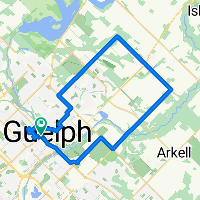
Guelph Lake second option
A cycling route starting in Guelph, Ontario, Canada.
Overview
About this route
- -:--
- Duration
- 38.6 km
- Distance
- 167 m
- Ascent
- 167 m
- Descent
- ---
- Avg. speed
- ---
- Max. altitude

Continue with Bikemap
Use, edit, or download this cycling route
You would like to ride Guelph Lake second option or customize it for your own trip? Here is what you can do with this Bikemap route:
Free features
- Save this route as favorite or in collections
- Copy & plan your own version of this route
- Sync your route with Garmin or Wahoo
Premium features
Free trial for 3 days, or one-time payment. More about Bikemap Premium.
- Navigate this route on iOS & Android
- Export a GPX / KML file of this route
- Create your custom printout (try it for free)
- Download this route for offline navigation
Discover more Premium features.
Get Bikemap PremiumFrom our community
Other popular routes starting in Guelph
 Guelph - Cambridge + Cambridge - Ancaster (1/2) (1/2) + Guelph - Cambridge + Cambridge - Ancaster (1/2) (2/2) + Guelph - Cambridge + Cambridge - Ancaster (2/2)
- Distance
- 55.1 km
- Ascent
- 192 m
- Descent
- 200 m
- Location
- Guelph, Ontario, Canada
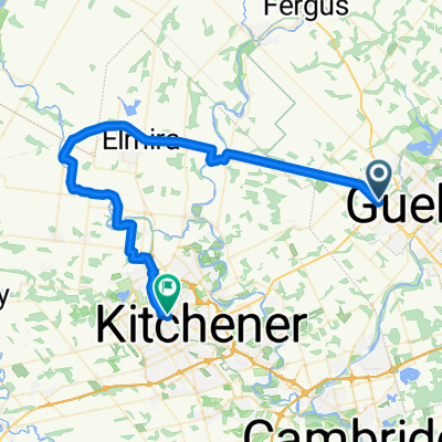
 16 Oxford St, Guelph to 16 Oxford St, Guelph
- Distance
- 23.9 km
- Ascent
- 357 m
- Descent
- 364 m
- Location
- Guelph, Ontario, Canada
 Guelph Perimeter
- Distance
- 56.9 km
- Ascent
- 210 m
- Descent
- 210 m
- Location
- Guelph, Ontario, Canada
 Niska Bridge
- Distance
- 25.3 km
- Ascent
- 105 m
- Descent
- 106 m
- Location
- Guelph, Ontario, Canada
 30K Victoria rec centre start
- Distance
- 30.1 km
- Ascent
- 145 m
- Descent
- 155 m
- Location
- Guelph, Ontario, Canada
 Guelph Lake second option
- Distance
- 38.6 km
- Ascent
- 167 m
- Descent
- 167 m
- Location
- Guelph, Ontario, Canada
 Guelph - North Perth
- Distance
- 50.1 km
- Ascent
- 206 m
- Descent
- 151 m
- Location
- Guelph, Ontario, Canada
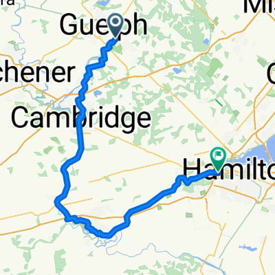 Latenda Pl, Guelph to Ofield Rd, Hamilton
- Distance
- 101.3 km
- Ascent
- 454 m
- Descent
- 690 m
- Location
- Guelph, Ontario, Canada
Open it in the app