
Spargelimport via CGN-Airport
A cycling route starting in Neustadt/Süd, North Rhine-Westphalia, Germany.
Overview
About this route
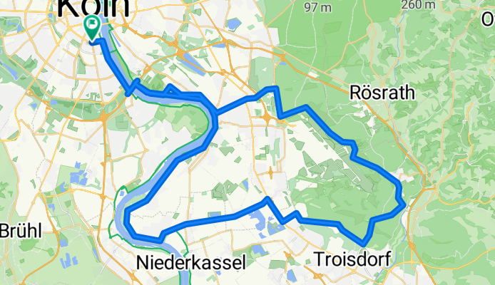
The asparagus season has just ended, but this route is an opportunity to take an airport loop throughout the season without having to struggle through the Porz street jungle on the way back.
First, it goes over Hirschgraben and Mauspfad to the airport, then to Altenrath and Spich. There, you turn left to Libur and reach the Rhein-Radweg via Ranzel and Lülsdorf.
In Lülsdorf and/or Langel, you can buy fresh asparagus directly from farmers and stuff it into your gym bag.
Warning: In good weather, especially after working hours and on public holidays, the Rhein-Radweg between Zündorf and Poll can be very crowded with walkers.
- -:--
- Duration
- 63.8 km
- Distance
- 176 m
- Ascent
- 176 m
- Descent
- ---
- Avg. speed
- ---
- Max. altitude

Route highlights
Points of interest along the route
Point of interest after 21 km
Laserpointer-freie Zone.
Point of interest after 44.4 km
Spargelhof
Point of interest after 47.8 km
Spargelhof
Continue with Bikemap
Use, edit, or download this cycling route
You would like to ride Spargelimport via CGN-Airport or customize it for your own trip? Here is what you can do with this Bikemap route:
Free features
- Save this route as favorite or in collections
- Copy & plan your own version of this route
- Sync your route with Garmin or Wahoo
Premium features
Free trial for 3 days, or one-time payment. More about Bikemap Premium.
- Navigate this route on iOS & Android
- Export a GPX / KML file of this route
- Create your custom printout (try it for free)
- Download this route for offline navigation
Discover more Premium features.
Get Bikemap PremiumFrom our community
Other popular routes starting in Neustadt/Süd
 Große Lindenthaler Runde
- Distance
- 51.4 km
- Ascent
- 150 m
- Descent
- 145 m
- Location
- Neustadt/Süd, North Rhine-Westphalia, Germany
 Runde knappsack Otto maigler
- Distance
- 36.7 km
- Ascent
- 957 m
- Descent
- 971 m
- Location
- Neustadt/Süd, North Rhine-Westphalia, Germany
 Flachetappe 130
- Distance
- 127.4 km
- Ascent
- 335 m
- Descent
- 328 m
- Location
- Neustadt/Süd, North Rhine-Westphalia, Germany
 Sülz - Glessener Höhe - Sülz
- Distance
- 43.2 km
- Ascent
- 184 m
- Descent
- 186 m
- Location
- Neustadt/Süd, North Rhine-Westphalia, Germany
 Grosse Bergrunde
- Distance
- 109.5 km
- Ascent
- 1,082 m
- Descent
- 1,087 m
- Location
- Neustadt/Süd, North Rhine-Westphalia, Germany
 Luxemburger Minirunde
- Distance
- 36.9 km
- Ascent
- 61 m
- Descent
- 63 m
- Location
- Neustadt/Süd, North Rhine-Westphalia, Germany
 lockere Trainingsrunde
- Distance
- 19.3 km
- Ascent
- 37 m
- Descent
- 35 m
- Location
- Neustadt/Süd, North Rhine-Westphalia, Germany
 NRW-RP
- Distance
- 77.6 km
- Ascent
- 270 m
- Descent
- 263 m
- Location
- Neustadt/Süd, North Rhine-Westphalia, Germany
Open it in the app