

Il Borgo Diffuso di San Michele
Sant'Angelo | Graffignano
A cycling route starting in Civitella d'Agliano, Lazio, Italy.
Overview
About this route
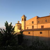
A ride through vineyards, white roads, fairy tales, and ancient villages. You will reach Sant'Angelo (the land of fairy tales), then Graffignano and Civitella d'Agliano.
- -:--
- Duration
- 22.9 km
- Distance
- 500 m
- Ascent
- 506 m
- Descent
- ---
- Avg. speed
- ---
- Max. altitude

Part of
Il Borgo Diffuso di San Michele
6 stages
Route quality
Waytypes & surfaces along the route
Waytypes
Quiet road
11.2 km
(49 %)
Track
3.7 km
(16 %)
Surfaces
Paved
6.2 km
(27 %)
Unpaved
5.3 km
(23 %)
Asphalt
6.2 km
(27 %)
Gravel
3.4 km
(15 %)
Continue with Bikemap
Use, edit, or download this cycling route
You would like to ride Sant'Angelo | Graffignano or customize it for your own trip? Here is what you can do with this Bikemap route:
Free features
- Save this route as favorite or in collections
- Copy & plan your own version of this route
- Sync your route with Garmin or Wahoo
Premium features
Free trial for 3 days, or one-time payment. More about Bikemap Premium.
- Navigate this route on iOS & Android
- Export a GPX / KML file of this route
- Create your custom printout (try it for free)
- Download this route for offline navigation
Discover more Premium features.
Get Bikemap PremiumFrom our community
Other popular routes starting in Civitella d'Agliano
 13 - Montefiascone - San Casciano Dei Bagni
- Distance
- 68.3 km
- Ascent
- 1,052 m
- Descent
- 748 m
- Location
- Civitella d'Agliano, Lazio, Italy
 La Valle del Tevere
- Distance
- 76.1 km
- Ascent
- 820 m
- Descent
- 827 m
- Location
- Civitella d'Agliano, Lazio, Italy
 Escursione nella Valle dei Calanchi
- Distance
- 51.4 km
- Ascent
- 871 m
- Descent
- 873 m
- Location
- Civitella d'Agliano, Lazio, Italy
 Il Giro del Lago di Bolsena
- Distance
- 80.5 km
- Ascent
- 669 m
- Descent
- 671 m
- Location
- Civitella d'Agliano, Lazio, Italy
 Sant'Angelo | Graffignano
- Distance
- 22.9 km
- Ascent
- 500 m
- Descent
- 506 m
- Location
- Civitella d'Agliano, Lazio, Italy
 L' Anello della Valle
- Distance
- 37.4 km
- Ascent
- 543 m
- Descent
- 543 m
- Location
- Civitella d'Agliano, Lazio, Italy
 Verso Civita di Bagnoregio
- Distance
- 38 km
- Ascent
- 621 m
- Descent
- 620 m
- Location
- Civitella d'Agliano, Lazio, Italy
 13c - Montefiascone - Monticello Amiata
- Distance
- 105.5 km
- Ascent
- 1,797 m
- Descent
- 1,376 m
- Location
- Civitella d'Agliano, Lazio, Italy
Open it in the app