

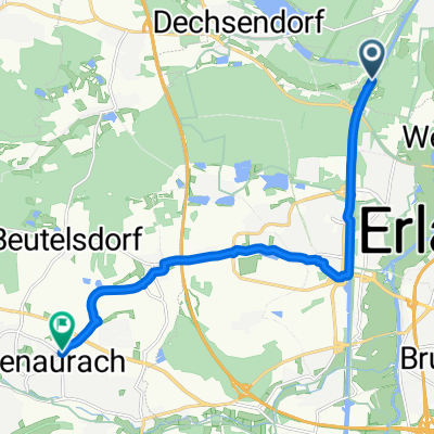
Möhrendorf-Adlitz-Runde
A cycling route starting in Möhrendorf, Bavaria, Germany.
Overview
About this route
Nice beer garden ride with a view
- -:--
- Duration
- 19.9 km
- Distance
- 144 m
- Ascent
- 148 m
- Descent
- ---
- Avg. speed
- 344 m
- Max. altitude
Route quality
Waytypes & surfaces along the route
Waytypes
Road
5.6 km
(28 %)
Quiet road
5 km
(25 %)
Surfaces
Paved
15.3 km
(77 %)
Unpaved
2.6 km
(13 %)
Asphalt
14.9 km
(75 %)
Gravel
1 km
(5 %)
Continue with Bikemap
Use, edit, or download this cycling route
You would like to ride Möhrendorf-Adlitz-Runde or customize it for your own trip? Here is what you can do with this Bikemap route:
Free features
- Save this route as favorite or in collections
- Copy & plan your own version of this route
- Sync your route with Garmin or Wahoo
Premium features
Free trial for 3 days, or one-time payment. More about Bikemap Premium.
- Navigate this route on iOS & Android
- Export a GPX / KML file of this route
- Create your custom printout (try it for free)
- Download this route for offline navigation
Discover more Premium features.
Get Bikemap PremiumFrom our community
Other popular routes starting in Möhrendorf
 Möhrendorf-Adlitz-Runde
- Distance
- 19.9 km
- Ascent
- 144 m
- Descent
- 148 m
- Location
- Möhrendorf, Bavaria, Germany
 2018-02-03 MTB Samstagstour
- Distance
- 37.5 km
- Ascent
- 198 m
- Descent
- 198 m
- Location
- Möhrendorf, Bavaria, Germany
 21.05.2009_Vatertagstour
- Distance
- 119 km
- Ascent
- 1,188 m
- Descent
- 1,193 m
- Location
- Möhrendorf, Bavaria, Germany
 kleine runde
- Distance
- 21.9 km
- Ascent
- 116 m
- Descent
- 116 m
- Location
- Möhrendorf, Bavaria, Germany
 Möhrendorf nach Rathgeberstraße, Herzogenaurach
- Distance
- 11.7 km
- Ascent
- 53 m
- Descent
- 22 m
- Location
- Möhrendorf, Bavaria, Germany
 RM-MTB__Erlangen-Kreuzbergkeller__51Km_420Hm
- Distance
- 51.2 km
- Ascent
- 423 m
- Descent
- 413 m
- Location
- Möhrendorf, Bavaria, Germany
 Möhrendorf Bamberg
- Distance
- 108.4 km
- Ascent
- 1,159 m
- Descent
- 1,160 m
- Location
- Möhrendorf, Bavaria, Germany
 Dammweiher
- Distance
- 9.4 km
- Ascent
- 74 m
- Descent
- 75 m
- Location
- Möhrendorf, Bavaria, Germany
Open it in the app