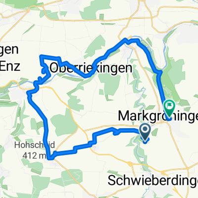
Enzweihingen-Schöckingen-Münchingen 34 km km
A cycling route starting in Markgröningen, Baden-Wurttemberg, Germany.
Overview
About this route
Training loop - Mkg - Pulverdingen - Enzweihingen - Hochdorf - Schöckingen - Münchingen - Mkg
- -:--
- Duration
- 33.9 km
- Distance
- 396 m
- Ascent
- 398 m
- Descent
- ---
- Avg. speed
- ---
- Max. altitude
Route quality
Waytypes & surfaces along the route
Waytypes
Track
17.3 km
(51 %)
Quiet road
7.1 km
(21 %)
Surfaces
Paved
31.9 km
(94 %)
Unpaved
0.3 km
(1 %)
Asphalt
29.2 km
(86 %)
Paved (undefined)
1.4 km
(4 %)
Continue with Bikemap
Use, edit, or download this cycling route
You would like to ride Enzweihingen-Schöckingen-Münchingen 34 km km or customize it for your own trip? Here is what you can do with this Bikemap route:
Free features
- Save this route as favorite or in collections
- Copy & plan your own version of this route
- Sync your route with Garmin or Wahoo
Premium features
Free trial for 3 days, or one-time payment. More about Bikemap Premium.
- Navigate this route on iOS & Android
- Export a GPX / KML file of this route
- Create your custom printout (try it for free)
- Download this route for offline navigation
Discover more Premium features.
Get Bikemap PremiumFrom our community
Other popular routes starting in Markgröningen
- Münchingen-Ditzingen--Vaihingen-Sachsenheim-Untermberg-Bissingen-Tamm-Mkg-55km
- Distance
- 55.3 km
- Ascent
- 460 m
- Descent
- 460 m
- Location
- Markgröningen, Baden-Wurttemberg, Germany
- Maulbronn 59 km
- Distance
- 58.9 km
- Ascent
- 378 m
- Descent
- 378 m
- Location
- Markgröningen, Baden-Wurttemberg, Germany
- Leonberg - Hochdorf 44 km
- Distance
- 44 km
- Ascent
- 349 m
- Descent
- 352 m
- Location
- Markgröningen, Baden-Wurttemberg, Germany
- Hochdorfer Tomatentour
- Distance
- 29.6 km
- Ascent
- 251 m
- Descent
- 251 m
- Location
- Markgröningen, Baden-Wurttemberg, Germany
- Enz-Metter-Tour
- Distance
- 62.8 km
- Ascent
- 594 m
- Descent
- 594 m
- Location
- Markgröningen, Baden-Wurttemberg, Germany
- Enzweihingen-Schöckingen-Münchingen 34 km km
- Distance
- 33.9 km
- Ascent
- 396 m
- Descent
- 398 m
- Location
- Markgröningen, Baden-Wurttemberg, Germany
- Glemsrunde
- Distance
- 47.8 km
- Ascent
- 271 m
- Descent
- 270 m
- Location
- Markgröningen, Baden-Wurttemberg, Germany
- Stromberg-Murrtal-Weg 66 km nach Maulbronn
- Distance
- 66.7 km
- Ascent
- 373 m
- Descent
- 376 m
- Location
- Markgröningen, Baden-Wurttemberg, Germany
Open it in the app