

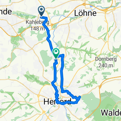
Kirchlengern nach Jöllenbeck Rundkurs
A cycling route starting in Kirchlengern, North Rhine-Westphalia, Germany.
Overview
About this route
From Kirchlengern via the WL to Jöllenbeck and back via the R47
- -:--
- Duration
- 38.7 km
- Distance
- 244 m
- Ascent
- 244 m
- Descent
- ---
- Avg. speed
- ---
- Max. altitude
Route quality
Waytypes & surfaces along the route
Waytypes
Quiet road
17 km
(44 %)
Cycleway
9.3 km
(24 %)
Surfaces
Paved
25.5 km
(66 %)
Unpaved
5.4 km
(14 %)
Asphalt
25.5 km
(66 %)
Gravel
3.1 km
(8 %)
Continue with Bikemap
Use, edit, or download this cycling route
You would like to ride Kirchlengern nach Jöllenbeck Rundkurs or customize it for your own trip? Here is what you can do with this Bikemap route:
Free features
- Save this route as favorite or in collections
- Copy & plan your own version of this route
- Sync your route with Garmin or Wahoo
Premium features
Free trial for 3 days, or one-time payment. More about Bikemap Premium.
- Navigate this route on iOS & Android
- Export a GPX / KML file of this route
- Create your custom printout (try it for free)
- Download this route for offline navigation
Discover more Premium features.
Get Bikemap PremiumFrom our community
Other popular routes starting in Kirchlengern
 Bünde nach Springe
- Distance
- 104.3 km
- Ascent
- 581 m
- Descent
- 505 m
- Location
- Kirchlengern, North Rhine-Westphalia, Germany
 Ein Stück von BoB
- Distance
- 111 km
- Ascent
- 1,279 m
- Descent
- 1,294 m
- Location
- Kirchlengern, North Rhine-Westphalia, Germany
 Quernheimer Straße 10, Kirchlengern nach Quernheimer Straße 10, Kirchlengern
- Distance
- 2.1 km
- Ascent
- 13 m
- Descent
- 13 m
- Location
- Kirchlengern, North Rhine-Westphalia, Germany
 Kaiser-Wilhem Denkmal
- Distance
- 52 km
- Ascent
- 139 m
- Descent
- 138 m
- Location
- Kirchlengern, North Rhine-Westphalia, Germany
 Elsestraße nach Tannenweg
- Distance
- 17.7 km
- Ascent
- 89 m
- Descent
- 96 m
- Location
- Kirchlengern, North Rhine-Westphalia, Germany
 Kirchlengern-Vlotho/Hafenstr.
- Distance
- 22.8 km
- Ascent
- 46 m
- Descent
- 54 m
- Location
- Kirchlengern, North Rhine-Westphalia, Germany
 Hiddenhsn_Stuckenberg
- Distance
- 21.4 km
- Ascent
- 139 m
- Descent
- 129 m
- Location
- Kirchlengern, North Rhine-Westphalia, Germany
 Erste Fahrt mit RTC Kirchlengern
- Distance
- 54.1 km
- Ascent
- 164 m
- Descent
- 174 m
- Location
- Kirchlengern, North Rhine-Westphalia, Germany
Open it in the app