

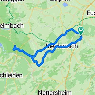
Schmidtheimer Runde
A cycling route starting in Mechernich, North Rhine-Westphalia, Germany.
Overview
About this route
- -:--
- Duration
- 80.5 km
- Distance
- 1,023 m
- Ascent
- 1,031 m
- Descent
- ---
- Avg. speed
- ---
- Max. altitude

Route quality
Waytypes & surfaces along the route
Waytypes
Path
16.9 km
(21 %)
Quiet road
11.3 km
(14 %)
Surfaces
Paved
67.6 km
(84 %)
Unpaved
3.2 km
(4 %)
Asphalt
63.6 km
(79 %)
Paved (undefined)
3.2 km
(4 %)
Continue with Bikemap
Use, edit, or download this cycling route
You would like to ride Schmidtheimer Runde or customize it for your own trip? Here is what you can do with this Bikemap route:
Free features
- Save this route as favorite or in collections
- Copy & plan your own version of this route
- Split it into stages to create a multi-day tour
- Sync your route with Garmin or Wahoo
Premium features
Free trial for 3 days, or one-time payment. More about Bikemap Premium.
- Navigate this route on iOS & Android
- Export a GPX / KML file of this route
- Create your custom printout (try it for free)
- Download this route for offline navigation
Discover more Premium features.
Get Bikemap PremiumFrom our community
Other popular routes starting in Mechernich
 Rundkurs Lessenich-Zingsheim-Lessenich über Römische Straße
- Distance
- 30.9 km
- Ascent
- 439 m
- Descent
- 436 m
- Location
- Mechernich, North Rhine-Westphalia, Germany
 Lessenich - Wolfgarten (Kermeter) und zurück
- Distance
- 46.4 km
- Ascent
- 457 m
- Descent
- 454 m
- Location
- Mechernich, North Rhine-Westphalia, Germany
 www.Rad-Rebellen.de - Tour 2
- Distance
- 32.1 km
- Ascent
- 408 m
- Descent
- 410 m
- Location
- Mechernich, North Rhine-Westphalia, Germany
 Querlenker Tour (35,09km, Start Firmenich)
- Distance
- 35.1 km
- Ascent
- 506 m
- Descent
- 508 m
- Location
- Mechernich, North Rhine-Westphalia, Germany
 Runde über Schleiden
- Distance
- 43.6 km
- Ascent
- 585 m
- Descent
- 574 m
- Location
- Mechernich, North Rhine-Westphalia, Germany
 Kommern-Nideggen-Heimbach-Kommern
- Distance
- 53.1 km
- Ascent
- 631 m
- Descent
- 631 m
- Location
- Mechernich, North Rhine-Westphalia, Germany
 Rund um den Rurstausee
- Distance
- 104.5 km
- Ascent
- 1,588 m
- Descent
- 1,609 m
- Location
- Mechernich, North Rhine-Westphalia, Germany
 Lessenich - Eschweilerbachtal- Lessenich
- Distance
- 24.5 km
- Ascent
- 244 m
- Descent
- 244 m
- Location
- Mechernich, North Rhine-Westphalia, Germany
Open it in the app