

Weigandstraße 14, Chemnitz nach An der Katze, Hohenstein-Ernstthal
A cycling route starting in Limbach-Oberfrohna, Saxony, Germany.
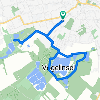
Overview
About this route
- 1 h
- Duration
- 15.3 km
- Distance
- 220 m
- Ascent
- 185 m
- Descent
- 15.3 km/h
- Avg. speed
- ---
- Max. altitude

Route photos


Route quality
Waytypes & surfaces along the route
Waytypes
Track
8.2 km
(54 %)
Quiet road
3.1 km
(20 %)
Surfaces
Paved
6.3 km
(41 %)
Unpaved
7.2 km
(47 %)
Asphalt
6 km
(39 %)
Gravel
6 km
(39 %)
Continue with Bikemap
Use, edit, or download this cycling route
You would like to ride Weigandstraße 14, Chemnitz nach An der Katze, Hohenstein-Ernstthal or customize it for your own trip? Here is what you can do with this Bikemap route:
Free features
- Save this route as favorite or in collections
- Copy & plan your own version of this route
- Sync your route with Garmin or Wahoo
Premium features
Free trial for 3 days, or one-time payment. More about Bikemap Premium.
- Navigate this route on iOS & Android
- Export a GPX / KML file of this route
- Create your custom printout (try it for free)
- Download this route for offline navigation
Discover more Premium features.
Get Bikemap PremiumFrom our community
Other popular routes starting in Limbach-Oberfrohna
 2008 Kändler - Fichtelberg (Käfi)
- Distance
- 67.4 km
- Ascent
- 1,021 m
- Descent
- 514 m
- Location
- Limbach-Oberfrohna, Saxony, Germany
 Silvestertour zur Naturrschutzstation "Am Sauwald" Dörfel
- Distance
- 59.4 km
- Ascent
- 748 m
- Descent
- 530 m
- Location
- Limbach-Oberfrohna, Saxony, Germany
 Heavy 24 (2013)
- Distance
- 8.6 km
- Ascent
- 117 m
- Descent
- 118 m
- Location
- Limbach-Oberfrohna, Saxony, Germany
 Mtb Tour Februar 2016
- Distance
- 33.3 km
- Ascent
- 328 m
- Descent
- 326 m
- Location
- Limbach-Oberfrohna, Saxony, Germany
 Radkriterium Niederfrohna
- Distance
- 2.5 km
- Ascent
- 21 m
- Descent
- 16 m
- Location
- Limbach-Oberfrohna, Saxony, Germany
 chemnitztal-rabenstein
- Distance
- 45.5 km
- Ascent
- 333 m
- Descent
- 340 m
- Location
- Limbach-Oberfrohna, Saxony, Germany
 KLEINE HAUSRUNDE
- Distance
- 5 km
- Ascent
- 33 m
- Descent
- 31 m
- Location
- Limbach-Oberfrohna, Saxony, Germany
 L.O. - Kohrener/Altenburger Land
- Distance
- 92.6 km
- Ascent
- 854 m
- Descent
- 937 m
- Location
- Limbach-Oberfrohna, Saxony, Germany
Open it in the app