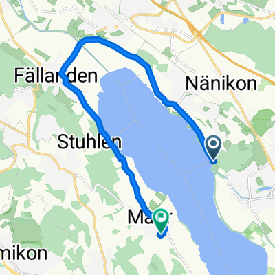
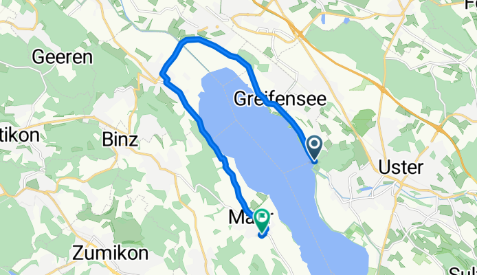
Moderate route in Maur
A cycling route starting in Uster / Nieder-Uster, Canton of Zurich, Switzerland.
Overview
About this route
- 43 min
- Duration
- 11.3 km
- Distance
- 64 m
- Ascent
- 38 m
- Descent
- 15.7 km/h
- Avg. speed
- ---
- Max. altitude
Route quality
Waytypes & surfaces along the route
Waytypes
Path
6.2 km
(55 %)
Road
2 km
(18 %)
Surfaces
Paved
11 km
(98 %)
Asphalt
11 km
(98 %)
Undefined
0.2 km
(2 %)
Continue with Bikemap
Use, edit, or download this cycling route
You would like to ride Moderate route in Maur or customize it for your own trip? Here is what you can do with this Bikemap route:
Free features
- Save this route as favorite or in collections
- Copy & plan your own version of this route
- Sync your route with Garmin or Wahoo
Premium features
Free trial for 3 days, or one-time payment. More about Bikemap Premium.
- Navigate this route on iOS & Android
- Export a GPX / KML file of this route
- Create your custom printout (try it for free)
- Download this route for offline navigation
Discover more Premium features.
Get Bikemap PremiumFrom our community
Other popular routes starting in Uster / Nieder-Uster
Greifenseerunde- Distance
- 19.3 km
- Ascent
- 88 m
- Descent
- 87 m
- Location
- Uster / Nieder-Uster, Canton of Zurich, Switzerland
Uster Triathlon 2024 (Mitteldistanz)- Distance
- 90.5 km
- Ascent
- 949 m
- Descent
- 947 m
- Location
- Uster / Nieder-Uster, Canton of Zurich, Switzerland
Moderate route in Maur- Distance
- 11.3 km
- Ascent
- 64 m
- Descent
- 38 m
- Location
- Uster / Nieder-Uster, Canton of Zurich, Switzerland
Pfannenstiel Hochwacht- Distance
- 10.7 km
- Ascent
- 386 m
- Descent
- 19 m
- Location
- Uster / Nieder-Uster, Canton of Zurich, Switzerland
Sonntag Morgen- Distance
- 14.8 km
- Ascent
- 169 m
- Descent
- 169 m
- Location
- Uster / Nieder-Uster, Canton of Zurich, Switzerland
Greifensee via Forch- Distance
- 27.8 km
- Ascent
- 318 m
- Descent
- 316 m
- Location
- Uster / Nieder-Uster, Canton of Zurich, Switzerland
Oberland Rundfahrt- Distance
- 64.4 km
- Ascent
- 1,201 m
- Descent
- 1,201 m
- Location
- Uster / Nieder-Uster, Canton of Zurich, Switzerland
Greifensee Rundweg CLONED FROM ROUTE 61100- Distance
- 19.3 km
- Ascent
- 69 m
- Descent
- 70 m
- Location
- Uster / Nieder-Uster, Canton of Zurich, Switzerland
Open it in the app


