Münchingen-Ditzingen--Vaihingen-Sachsenheim-Untermberg-Bissingen-Tamm-Mkg-55km
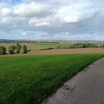
A cycling route starting in Markgröningen, Baden-Württemberg, Germany.
Overview
About this route
Mkg - Münchingen - Ditzingen - Hirschlanden - Heimerdingen - Eberdingen - Riet - Enzweihingen - Vaihingen - Sersheim - Sachsenheim - Untermberg - Bissingen - Tamm - Mkg
- -:--
- Duration
- 55.3 km
- Distance
- 460 m
- Ascent
- 460 m
- Descent
- ---
- Avg. speed
- ---
- Avg. speed
Route quality
Waytypes & surfaces along the route
Waytypes
Track
27.2 km
(49 %)
Quiet road
10.8 km
(20 %)
Surfaces
Paved
48.5 km
(88 %)
Unpaved
3.5 km
(6 %)
Asphalt
46.9 km
(85 %)
Gravel
2.4 km
(4 %)
Continue with Bikemap
Use, edit, or download this cycling route
You would like to ride Münchingen-Ditzingen--Vaihingen-Sachsenheim-Untermberg-Bissingen-Tamm-Mkg-55km or customize it for your own trip? Here is what you can do with this Bikemap route:
Free features
- Save this route as favorite or in collections
- Copy & plan your own version of this route
- Sync your route with Garmin or Wahoo
Premium features
Free trial for 3 days, or one-time payment. More about Bikemap Premium.
- Navigate this route on iOS & Android
- Export a GPX / KML file of this route
- Create your custom printout (try it for free)
- Download this route for offline navigation
Discover more Premium features.
Get Bikemap PremiumFrom our community
Other popular routes starting in Markgröningen
- Mlg--Vaihingen-Sachsenheim-BiBi-Tamm-Mkg-47km
- Distance
- 47.4 km
- Ascent
- 392 m
- Descent
- 392 m
- Location
- Markgröningen, Baden-Württemberg, Germany
- Markgröningen nach Hohenstein
- Distance
- 90.4 km
- Ascent
- 1,270 m
- Descent
- 816 m
- Location
- Markgröningen, Baden-Württemberg, Germany
- Maulbronn 59 km
- Distance
- 58.9 km
- Ascent
- 378 m
- Descent
- 378 m
- Location
- Markgröningen, Baden-Württemberg, Germany
- Leonberg - Hochdorf 44 km
- Distance
- 44 km
- Ascent
- 349 m
- Descent
- 352 m
- Location
- Markgröningen, Baden-Württemberg, Germany
- Max-Eyth-See kurz
- Distance
- 42.6 km
- Ascent
- 246 m
- Descent
- 245 m
- Location
- Markgröningen, Baden-Württemberg, Germany
- Hochdorfer Tomatentour
- Distance
- 29.6 km
- Ascent
- 251 m
- Descent
- 251 m
- Location
- Markgröningen, Baden-Württemberg, Germany
- Enzweihingen-Schöckingen-Münchingen 34 km km
- Distance
- 33.9 km
- Ascent
- 396 m
- Descent
- 398 m
- Location
- Markgröningen, Baden-Württemberg, Germany
- Münchingen-Ditzingen--Vaihingen-Sachsenheim-Untermberg-Bissingen-Tamm-Mkg-55km
- Distance
- 55.3 km
- Ascent
- 460 m
- Descent
- 460 m
- Location
- Markgröningen, Baden-Württemberg, Germany
Open it in the app