

Schnelle Tour in kalchreuth
A cycling route starting in Kalchreuth, Bavaria, Germany.
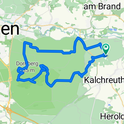
Overview
About this route
- 30 min
- Duration
- 14.2 km
- Distance
- 43 m
- Ascent
- 141 m
- Descent
- 28.9 km/h
- Avg. speed
- ---
- Max. altitude

Route photos

Route quality
Waytypes & surfaces along the route
Waytypes
Track
4.6 km
(32 %)
Path
3.8 km
(27 %)
Surfaces
Paved
8.3 km
(58 %)
Unpaved
5.1 km
(36 %)
Asphalt
7.7 km
(54 %)
Gravel
4.3 km
(30 %)
Continue with Bikemap
Use, edit, or download this cycling route
You would like to ride Schnelle Tour in kalchreuth or customize it for your own trip? Here is what you can do with this Bikemap route:
Free features
- Save this route as favorite or in collections
- Copy & plan your own version of this route
- Sync your route with Garmin or Wahoo
Premium features
Free trial for 3 days, or one-time payment. More about Bikemap Premium.
- Navigate this route on iOS & Android
- Export a GPX / KML file of this route
- Create your custom printout (try it for free)
- Download this route for offline navigation
Discover more Premium features.
Get Bikemap PremiumFrom our community
Other popular routes starting in Kalchreuth
 Von Kalchreuth über Gräfenberg nach Schnaitach und über Neunhof zurück
- Distance
- 60.5 km
- Ascent
- 463 m
- Descent
- 462 m
- Location
- Kalchreuth, Bavaria, Germany
 Reichswaldtour (ca. 35km)
- Distance
- 34.9 km
- Ascent
- 209 m
- Descent
- 209 m
- Location
- Kalchreuth, Bavaria, Germany
 D_Bayern_Nürnberg-Singletrail02_Kalchreuth-Kahlberg
- Distance
- 0.9 km
- Ascent
- 8 m
- Descent
- 47 m
- Location
- Kalchreuth, Bavaria, Germany
 Klettertouren Rund um Kirchsittenbach
- Distance
- 117 km
- Ascent
- 1,172 m
- Descent
- 1,172 m
- Location
- Kalchreuth, Bavaria, Germany
 Ausflugsrunde 2013-10-03 (ca. 26km)
- Distance
- 25.6 km
- Ascent
- 168 m
- Descent
- 169 m
- Location
- Kalchreuth, Bavaria, Germany
 Rund um Kalchreuth
- Distance
- 44.6 km
- Ascent
- 417 m
- Descent
- 529 m
- Location
- Kalchreuth, Bavaria, Germany
 D_Bayern_Nürnberg-Singletrail03_Kalchreuth-Teufelstisch
- Distance
- 1 km
- Ascent
- 0 m
- Descent
- 42 m
- Location
- Kalchreuth, Bavaria, Germany
 NU__Forchheim__Obertrubach_Graefenberg__NU
- Distance
- 99.1 km
- Ascent
- 527 m
- Descent
- 554 m
- Location
- Kalchreuth, Bavaria, Germany
Open it in the app