LF6 Vl Fietsroute
A cycling route starting in Alveringem, Flemish Region, Belgium.
Overview
About this route
Go the challenge and feel powerful on the peaks of the Flemish Hills! With its 360 km, the LF 6, the southern arm of the Flanders Cycling Route, is also the longest section of this Flemish loop. Cycling from Kanne to Vleteren, you discover another side of the versatile Flemish landscape. The flat Maasland is exchanged for the hilly landscapes of Haspengouw, Hageland, Pajottenland, and the Flemish Ardennes. The route takes you past stunning panoramas and picturesque villages. Bike-friendly paths wind through the rolling landscapes without putting your physical condition to the test too much, but just a little. From Kanne, it is also possible to follow the LF 6 Connecting Route in a northeast direction. This connects to the Dutch LF 6 which ensures the connection with the LF 3 Maasroute and the German city of Aachen. In Aachen, you can then switch to the German cycling network.
- -:--
- Duration
- 563.5 km
- Distance
- 2,550 m
- Ascent
- 2,552 m
- Descent
- ---
- Avg. speed
- ---
- Max. altitude
Route quality
Waytypes & surfaces along the route
Waytypes
Quiet road
281.8 km
(50 %)
Cycleway
95.8 km
(17 %)
Surfaces
Paved
377.5 km
(67 %)
Unpaved
22.5 km
(4 %)
Asphalt
270.5 km
(48 %)
Concrete
95.8 km
(17 %)
Continue with Bikemap
Use, edit, or download this cycling route
You would like to ride LF6 Vl Fietsroute or customize it for your own trip? Here is what you can do with this Bikemap route:
Free features
- Save this route as favorite or in collections
- Copy & plan your own version of this route
- Split it into stages to create a multi-day tour
- Sync your route with Garmin or Wahoo
Premium features
Free trial for 3 days, or one-time payment. More about Bikemap Premium.
- Navigate this route on iOS & Android
- Export a GPX / KML file of this route
- Create your custom printout (try it for free)
- Download this route for offline navigation
Discover more Premium features.
Get Bikemap PremiumFrom our community
Other popular routes starting in Alveringem
- 20160622_094445.gpx
- Distance
- 32.7 km
- Ascent
- 5 m
- Descent
- 10 m
- Location
- Alveringem, Flemish Region, Belgium
- Beveren-Zuytcoote.gpx
- Distance
- 32.1 km
- Ascent
- 8 m
- Descent
- 14 m
- Location
- Alveringem, Flemish Region, Belgium
- pollinkhove-brakel.parike bivak-112km
- Distance
- 111.7 km
- Ascent
- 456 m
- Descent
- 390 m
- Location
- Alveringem, Flemish Region, Belgium
- Roesbruggestraat 19, Alveringem naar Roesbruggestraat 19, Alveringem
- Distance
- 8.5 km
- Ascent
- 8 m
- Descent
- 10 m
- Location
- Alveringem, Flemish Region, Belgium
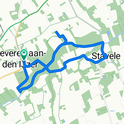
- Schrevepromenade 2025 - de 25km
- Distance
- 30.2 km
- Ascent
- 50 m
- Descent
- 51 m
- Location
- Alveringem, Flemish Region, Belgium
- LF6 Vl Fietsroute
- Distance
- 563.5 km
- Ascent
- 2,550 m
- Descent
- 2,552 m
- Location
- Alveringem, Flemish Region, Belgium
- Avondrit: Oost-Cappel - Rexpoëde - Killem - Hondschoote - Houtem
- Distance
- 27.3 km
- Ascent
- 54 m
- Descent
- 63 m
- Location
- Alveringem, Flemish Region, Belgium
- polinkhove - 43.2
- Distance
- 43.2 km
- Ascent
- 72 m
- Descent
- 72 m
- Location
- Alveringem, Flemish Region, Belgium
Open it in the app