

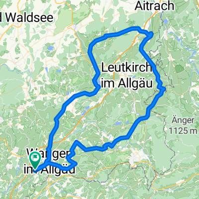
Wangen - Geiselharz - Reute - Spiesberg - Kugelhäusle (steiler Anstieg) - Lerchensang - Karbach - Wangen
A cycling route starting in Wangen, Baden-Wurttemberg, Germany.
Overview
About this route
Landschaftlich reizvolle Strecke mit mehreren steilen Anstiegen/Abfahrten überwiegend auf Nebenstraßen. Die Tour führt ausschließlich auf asphaltierten Nebenstraßen/Radwegen und ist auch für Rennradfahrer geeignet.
- -:--
- Duration
- 30.7 km
- Distance
- 546 m
- Ascent
- 545 m
- Descent
- ---
- Avg. speed
- 679 m
- Max. altitude

Route photos
 - Lerchensang - Karbach - Wangen\"")
 - Lerchensang - Karbach - Wangen\"")
 - Lerchensang - Karbach - Wangen\"")
 - Lerchensang - Karbach - Wangen\"")
 - Lerchensang - Karbach - Wangen\"")
Route quality
Waytypes & surfaces along the route
Waytypes
Quiet road
21.4 km
(70 %)
Road
3.3 km
(11 %)
Surfaces
Paved
24.9 km
(81 %)
Unpaved
0.2 km
(<1 %)
Asphalt
24.9 km
(81 %)
Gravel
0.2 km
(<1 %)
Continue with Bikemap
Use, edit, or download this cycling route
You would like to ride Wangen - Geiselharz - Reute - Spiesberg - Kugelhäusle (steiler Anstieg) - Lerchensang - Karbach - Wangen or customize it for your own trip? Here is what you can do with this Bikemap route:
Free features
- Save this route as favorite or in collections
- Copy & plan your own version of this route
- Sync your route with Garmin or Wahoo
Premium features
Free trial for 3 days, or one-time payment. More about Bikemap Premium.
- Navigate this route on iOS & Android
- Export a GPX / KML file of this route
- Create your custom printout (try it for free)
- Download this route for offline navigation
Discover more Premium features.
Get Bikemap PremiumFrom our community
Other popular routes starting in Wangen
 2025 Tour 2 Barockstr. 16.06.25
- Distance
- 99.6 km
- Ascent
- 1,199 m
- Descent
- 1,198 m
- Location
- Wangen, Baden-Wurttemberg, Germany
 Deutsche Strassenmeisterschaft 2013 Frauen / Elite Männer
- Distance
- 42.2 km
- Ascent
- 415 m
- Descent
- 415 m
- Location
- Wangen, Baden-Wurttemberg, Germany
 Allgäu Rundfahrt eines bekannten MTB Sportvereins...
- Distance
- 47.7 km
- Ascent
- 653 m
- Descent
- 651 m
- Location
- Wangen, Baden-Wurttemberg, Germany
 Missener Hausrunde
- Distance
- 18.5 km
- Ascent
- 287 m
- Descent
- 295 m
- Location
- Wangen, Baden-Wurttemberg, Germany
 Nordrunde Wangen
- Distance
- 21.4 km
- Ascent
- 311 m
- Descent
- 311 m
- Location
- Wangen, Baden-Wurttemberg, Germany
 Runde auf ruhigen Straßen
- Distance
- 22.8 km
- Ascent
- 151 m
- Descent
- 151 m
- Location
- Wangen, Baden-Wurttemberg, Germany
 Wangen trail
- Distance
- 28.3 km
- Ascent
- 295 m
- Descent
- 268 m
- Location
- Wangen, Baden-Wurttemberg, Germany
 Mountainbiketour 2014
- Distance
- 41 km
- Ascent
- 268 m
- Descent
- 274 m
- Location
- Wangen, Baden-Wurttemberg, Germany
Open it in the app