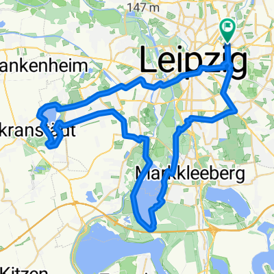
Leipzig - Grimma
A cycling route starting in Leipzig, Saxony, Germany.
Overview
About this route
Relaxed tour along the Pleiße, Markleeberger Lake, and Störmthaler Lake through the forest and across the fields.
Minimal road usage!
- -:--
- Duration
- 34.8 km
- Distance
- 110 m
- Ascent
- 89 m
- Descent
- ---
- Avg. speed
- ---
- Max. altitude
Route quality
Waytypes & surfaces along the route
Waytypes
Track
17.8 km
(51 %)
Quiet road
8.4 km
(24 %)
Surfaces
Paved
19.9 km
(57 %)
Unpaved
11.1 km
(32 %)
Asphalt
19.9 km
(57 %)
Gravel
6.6 km
(19 %)
Route highlights
Points of interest along the route
Point of interest after 6.2 km
Point of interest after 14.3 km
Point of interest after 17.5 km
Point of interest after 20.2 km
Continue with Bikemap
Use, edit, or download this cycling route
You would like to ride Leipzig - Grimma or customize it for your own trip? Here is what you can do with this Bikemap route:
Free features
- Save this route as favorite or in collections
- Copy & plan your own version of this route
- Sync your route with Garmin or Wahoo
Premium features
Free trial for 3 days, or one-time payment. More about Bikemap Premium.
- Navigate this route on iOS & Android
- Export a GPX / KML file of this route
- Create your custom printout (try it for free)
- Download this route for offline navigation
Discover more Premium features.
Get Bikemap PremiumFrom our community
Other popular routes starting in Leipzig
- Leipzig - Grimma
- Distance
- 34.8 km
- Ascent
- 110 m
- Descent
- 89 m
- Location
- Leipzig, Saxony, Germany
- Markleeberger u. Cospudener See
- Distance
- 37.6 km
- Ascent
- 61 m
- Descent
- 59 m
- Location
- Leipzig, Saxony, Germany
- 1. Tag Saale-Radweg
- Distance
- 66.3 km
- Ascent
- 130 m
- Descent
- 130 m
- Location
- Leipzig, Saxony, Germany
- Kreuz uns Quer durchs Muldental
- Distance
- 137.1 km
- Ascent
- 558 m
- Descent
- 545 m
- Location
- Leipzig, Saxony, Germany
- Rochlitz über Ceesewitz
- Distance
- 124.5 km
- Ascent
- 572 m
- Descent
- 572 m
- Location
- Leipzig, Saxony, Germany
- Gohlis - Dölitz mit Clarapark und Auwald
- Distance
- 15.3 km
- Ascent
- 72 m
- Descent
- 55 m
- Location
- Leipzig, Saxony, Germany
- Rundfahrt LE Süd
- Distance
- 66.7 km
- Ascent
- 0 m
- Descent
- 0 m
- Location
- Leipzig, Saxony, Germany
- Durch den Südraum von Leipzg
- Distance
- 63.7 km
- Ascent
- 119 m
- Descent
- 108 m
- Location
- Leipzig, Saxony, Germany
Open it in the app