- 39.2 km
- 168 m
- 168 m
- Unterschneidheim, Baden-Wurttemberg, Germany
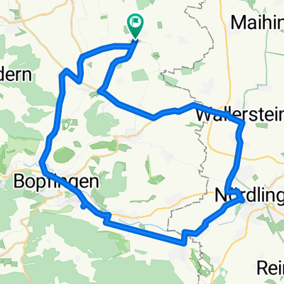
Nördlinger Nordwest-Schleife
A cycling route starting in Unterschneidheim, Baden-Wurttemberg, Germany.
Overview
About this route
A small loop through the northwest of the Nördlinger Ries. In addition to the impressive Ries landscape, especially the beautiful cycle paths between Bopfingen and Nördlingen are appealing, offering plenty of variation and extension options.
The roads along the main traffic axes are unfortunately sometimes 'blessed' with higher traffic volumes. Those who don't like this can usually detour onto quieter side routes.
Especially beautiful in midsummer towards evening! There you have a wonderful, extra-long sunset!
- -:--
- Duration
- 39.2 km
- Distance
- 168 m
- Ascent
- 168 m
- Descent
- ---
- Avg. speed
- ---
- Max. altitude
Continue with Bikemap
Use, edit, or download this cycling route
You would like to ride Nördlinger Nordwest-Schleife or customize it for your own trip? Here is what you can do with this Bikemap route:
Free features
- Save this route as favorite or in collections
- Copy & plan your own version of this route
- Sync your route with Garmin or Wahoo
Premium features
Free trial for 3 days, or one-time payment. More about Bikemap Premium.
- Navigate this route on iOS & Android
- Export a GPX / KML file of this route
- Create your custom printout (try it for free)
- Download this route for offline navigation
Discover more Premium features.
Get Bikemap PremiumFrom our community
Other popular routes starting in Unterschneidheim
- Nördlinger Nordwest-Schleife
- ??¥œ? nach ??¥œ?
- 19.4 km
- 217 m
- 248 m
- Unterschneidheim, Baden-Wurttemberg, Germany
- Jagstursprung-Crailsheim
- 53.9 km
- 96 m
- 207 m
- Unterschneidheim, Baden-Wurttemberg, Germany
- Deutschordenstraße 6, Unterschneidheim nach Baldinger Straße 34, Nördlingen
- 12.2 km
- 38 m
- 114 m
- Unterschneidheim, Baden-Wurttemberg, Germany
- mittel strecke
- 6.8 km
- 82 m
- 86 m
- Unterschneidheim, Baden-Wurttemberg, Germany
- Jagst-Radweg Walxheim - Kirchberg Tag1
- 77 km
- 179 m
- 283 m
- Unterschneidheim, Baden-Wurttemberg, Germany
- Schillerstraße 5, Unterschneidheim nach Schillerstraße 5, Unterschneidheim
- 13.7 km
- 93 m
- 138 m
- Unterschneidheim, Baden-Wurttemberg, Germany
- Einfache Fahrt in Bopfingen
- 4 km
- 8 m
- 24 m
- Unterschneidheim, Baden-Wurttemberg, Germany
Open it in the app


