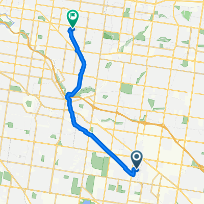
Oakleigh East to to Boronia
A cycling route starting in Clayton, Victoria, Australia.
Overview
About this route
Takes the back roads and paths to Dandenong Creek trail then travels to Boronia railway station
- 3 h 34 min
- Duration
- 22.7 km
- Distance
- 171 m
- Ascent
- 156 m
- Descent
- 6.4 km/h
- Avg. speed
- 116 m
- Avg. speed
Route quality
Waytypes & surfaces along the route
Waytypes
Cycleway
16.1 km
(71 %)
Quiet road
3.9 km
(17 %)
Surfaces
Paved
13.5 km
(60 %)
Unpaved
0.1 km
(<1 %)
Asphalt
10 km
(44 %)
Concrete
3.5 km
(15 %)
Continue with Bikemap
Use, edit, or download this cycling route
You would like to ride Oakleigh East to to Boronia or customize it for your own trip? Here is what you can do with this Bikemap route:
Free features
- Save this route as favorite or in collections
- Copy & plan your own version of this route
- Sync your route with Garmin or Wahoo
Premium features
Free trial for 3 days, or one-time payment. More about Bikemap Premium.
- Navigate this route on iOS & Android
- Export a GPX / KML file of this route
- Create your custom printout (try it for free)
- Download this route for offline navigation
Discover more Premium features.
Get Bikemap PremiumFrom our community
Other popular routes starting in Clayton
- Mordialloc Freeway
- Distance
- 32.3 km
- Ascent
- 4 m
- Descent
- 25 m
- Location
- Clayton, Victoria, Australia
- 05022018
- Distance
- 17.9 km
- Ascent
- 89 m
- Descent
- 56 m
- Location
- Clayton, Victoria, Australia
- 50KM Loop to Mitcham
- Distance
- 48.9 km
- Ascent
- 281 m
- Descent
- 278 m
- Location
- Clayton, Victoria, Australia
- Capital P
- Distance
- 43.2 km
- Ascent
- 310 m
- Descent
- 376 m
- Location
- Clayton, Victoria, Australia
- Loop to Ringwood Lake
- Distance
- 58.3 km
- Ascent
- 323 m
- Descent
- 326 m
- Location
- Clayton, Victoria, Australia
- Recording from November 16, 18:16
- Distance
- 26.7 km
- Ascent
- 228 m
- Descent
- 228 m
- Location
- Clayton, Victoria, Australia
- 21 Eva St, Clayton to 162 Palm Beach Dr, Patterson Lakes
- Distance
- 33 km
- Ascent
- 64 m
- Descent
- 120 m
- Location
- Clayton, Victoria, Australia
- 5km Radius - Bike Route 3
- Distance
- 15.4 km
- Ascent
- 77 m
- Descent
- 80 m
- Location
- Clayton, Victoria, Australia
Open it in the app