

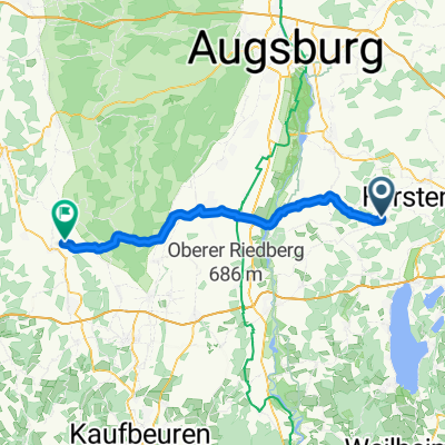
Rundfahrt über St. Ottilien
A cycling route starting in Moorenweis, Bavaria, Germany.
Overview
About this route
- 2 h 53 min
- Duration
- 29.2 km
- Distance
- 156 m
- Ascent
- 155 m
- Descent
- 10.1 km/h
- Avg. speed
- ---
- Max. altitude
Route quality
Waytypes & surfaces along the route
Waytypes
Quiet road
16.1 km
(55 %)
Track
9.4 km
(32 %)
Surfaces
Paved
16.8 km
(58 %)
Unpaved
9.7 km
(33 %)
Asphalt
16.4 km
(56 %)
Gravel
9.3 km
(32 %)
Continue with Bikemap
Use, edit, or download this cycling route
You would like to ride Rundfahrt über St. Ottilien or customize it for your own trip? Here is what you can do with this Bikemap route:
Free features
- Save this route as favorite or in collections
- Copy & plan your own version of this route
- Sync your route with Garmin or Wahoo
Premium features
Free trial for 3 days, or one-time payment. More about Bikemap Premium.
- Navigate this route on iOS & Android
- Export a GPX / KML file of this route
- Create your custom printout (try it for free)
- Download this route for offline navigation
Discover more Premium features.
Get Bikemap PremiumFrom our community
Other popular routes starting in Moorenweis
 Moorenweis - Salgen
- Distance
- 55.5 km
- Ascent
- 214 m
- Descent
- 217 m
- Location
- Moorenweis, Bavaria, Germany
 Am Stiegelfeld 34A, Moorenweis nach Kirchstraße 3, Steindorf
- Distance
- 10.1 km
- Ascent
- 41 m
- Descent
- 76 m
- Location
- Moorenweis, Bavaria, Germany
 Flache Nordrunde (kopiert von Thorsten)
- Distance
- 67.6 km
- Ascent
- 254 m
- Descent
- 254 m
- Location
- Moorenweis, Bavaria, Germany
 Hohenpeißenberg und zurück
- Distance
- 124 km
- Ascent
- 962 m
- Descent
- 962 m
- Location
- Moorenweis, Bavaria, Germany
 Rundfahrt über St. Ottilien
- Distance
- 29.2 km
- Ascent
- 156 m
- Descent
- 155 m
- Location
- Moorenweis, Bavaria, Germany
 Eismerszell Rundkurs Nord
- Distance
- 40.5 km
- Ascent
- 101 m
- Descent
- 101 m
- Location
- Moorenweis, Bavaria, Germany
 SoTo 2018/3: Moorenweis - Bad Kohlgrub
- Distance
- 99.8 km
- Ascent
- 555 m
- Descent
- 221 m
- Location
- Moorenweis, Bavaria, Germany
 Gewerbering 2, Moorenweis nach Kirchstraße 22, Jesenwang
- Distance
- 4.8 km
- Ascent
- 13 m
- Descent
- 13 m
- Location
- Moorenweis, Bavaria, Germany
Open it in the app