

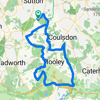
Farthing Down, Chipstead and Banstead from Carshalton Beeches
A cycling route starting in Sutton, England, United Kingdom.
Overview
About this route
Glorious countryside ride over rolling hills. Stunning views over Farthing Downs, virtually traffic-free most of the way
- -:--
- Duration
- 36.6 km
- Distance
- 476 m
- Ascent
- 476 m
- Descent
- ---
- Avg. speed
- ---
- Max. altitude
Route quality
Waytypes & surfaces along the route
Waytypes
Road
11.7 km
(32 %)
Quiet road
11 km
(30 %)
Surfaces
Paved
17.9 km
(49 %)
Asphalt
17.9 km
(49 %)
Undefined
18.7 km
(51 %)
Continue with Bikemap
Use, edit, or download this cycling route
You would like to ride Farthing Down, Chipstead and Banstead from Carshalton Beeches or customize it for your own trip? Here is what you can do with this Bikemap route:
Free features
- Save this route as favorite or in collections
- Copy & plan your own version of this route
- Sync your route with Garmin or Wahoo
Premium features
Free trial for 3 days, or one-time payment. More about Bikemap Premium.
- Navigate this route on iOS & Android
- Export a GPX / KML file of this route
- Create your custom printout (try it for free)
- Download this route for offline navigation
Discover more Premium features.
Get Bikemap PremiumFrom our community
Other popular routes starting in Sutton
 Cheam Epsom Headley BoxHill Ranmore
- Distance
- 89.4 km
- Ascent
- 869 m
- Descent
- 867 m
- Location
- Sutton, England, United Kingdom
 ride from (null) to (null)
- Distance
- 10 km
- Ascent
- ---
- Descent
- ---
- Location
- Sutton, England, United Kingdom
 Cheam NewlandsCorner Box Hill
- Distance
- 66.4 km
- Ascent
- 509 m
- Descent
- 507 m
- Location
- Sutton, England, United Kingdom
 Farthing Down, Chipstead and Banstead from Carshalton Beeches
- Distance
- 36.6 km
- Ascent
- 476 m
- Descent
- 476 m
- Location
- Sutton, England, United Kingdom
 Sutton to Brighton
- Distance
- 78.3 km
- Ascent
- 381 m
- Descent
- 429 m
- Location
- Sutton, England, United Kingdom
 BikemaptoFiona
- Distance
- 76.9 km
- Ascent
- 395 m
- Descent
- 383 m
- Location
- Sutton, England, United Kingdom
 Sutton Epsom Downs Circular 1
- Distance
- 83.5 km
- Ascent
- 855 m
- Descent
- 855 m
- Location
- Sutton, England, United Kingdom
 Pearson Sportive route
- Distance
- 150.4 km
- Ascent
- 929 m
- Descent
- 931 m
- Location
- Sutton, England, United Kingdom
Open it in the app