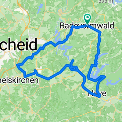
BL18_Spieckern-Herbringhausen
A cycling route starting in Radevormwald, North Rhine-Westphalia, Germany.
Overview
About this route
Start: P-Spieckern
Über: Kotthausen - Hof Sondern - Herbringhauser Talsperre
Ziel: P-Spieckern
- -:--
- Duration
- 7.7 km
- Distance
- 183 m
- Ascent
- 182 m
- Descent
- ---
- Avg. speed
- ---
- Max. altitude
Route quality
Waytypes & surfaces along the route
Waytypes
Quiet road
3.2 km
(42 %)
Track
1.5 km
(20 %)
Surfaces
Paved
6.5 km
(84 %)
Unpaved
1.2 km
(16 %)
Asphalt
6.5 km
(84 %)
Gravel
0.5 km
(6 %)
Continue with Bikemap
Use, edit, or download this cycling route
You would like to ride BL18_Spieckern-Herbringhausen or customize it for your own trip? Here is what you can do with this Bikemap route:
Free features
- Save this route as favorite or in collections
- Copy & plan your own version of this route
- Sync your route with Garmin or Wahoo
Premium features
Free trial for 3 days, or one-time payment. More about Bikemap Premium.
- Navigate this route on iOS & Android
- Export a GPX / KML file of this route
- Create your custom printout (try it for free)
- Download this route for offline navigation
Discover more Premium features.
Get Bikemap PremiumFrom our community
Other popular routes starting in Radevormwald
- 27.11.2010 Krähwinkel 1 Rund um die Wuppertalsperre
- Distance
- 19.8 km
- Ascent
- 259 m
- Descent
- 259 m
- Location
- Radevormwald, North Rhine-Westphalia, Germany
- Von Talsperren und Bahntrassen– Graveln im Bergischen
- Distance
- 48.8 km
- Ascent
- 474 m
- Descent
- 476 m
- Location
- Radevormwald, North Rhine-Westphalia, Germany
- Adler RTF 41er bis 2008
- Distance
- 36 km
- Ascent
- 376 m
- Descent
- 395 m
- Location
- Radevormwald, North Rhine-Westphalia, Germany
- Runde Röntgenlauf
- Distance
- 62.2 km
- Ascent
- 1,152 m
- Descent
- 1,191 m
- Location
- Radevormwald, North Rhine-Westphalia, Germany
- Kräwinkel - Marscheider Bachtal
- Distance
- 41.7 km
- Ascent
- 648 m
- Descent
- 647 m
- Location
- Radevormwald, North Rhine-Westphalia, Germany
- Radevormwald-Ennepetalsperre-Halver
- Distance
- 31.6 km
- Ascent
- 328 m
- Descent
- 328 m
- Location
- Radevormwald, North Rhine-Westphalia, Germany
- R2 - Entlang der Ülfe und der Wupper
- Distance
- 25.6 km
- Ascent
- 276 m
- Descent
- 276 m
- Location
- Radevormwald, North Rhine-Westphalia, Germany
- Tannenbergweg 3, Radevormwald nach Tannenbergweg 3, Radevormwald
- Distance
- 4.2 km
- Ascent
- 4 m
- Descent
- 23 m
- Location
- Radevormwald, North Rhine-Westphalia, Germany
Open it in the app