
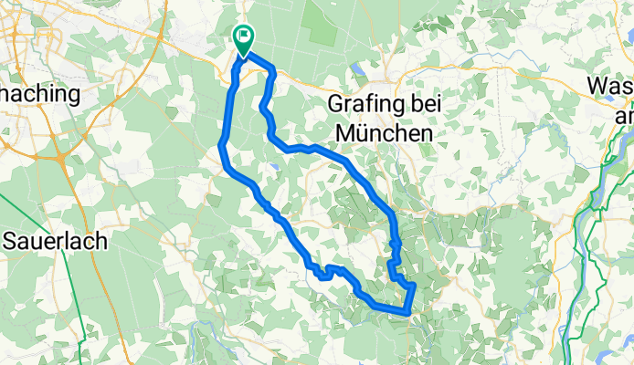
Piusheim
A cycling route starting in Zorneding, Bavaria, Germany.
Overview
About this route
- -:--
- Duration
- 58.2 km
- Distance
- 364 m
- Ascent
- 368 m
- Descent
- ---
- Avg. speed
- ---
- Max. altitude
Route quality
Waytypes & surfaces along the route
Waytypes
Quiet road
32 km
(55 %)
Road
12.8 km
(22 %)
Surfaces
Paved
53.5 km
(92 %)
Unpaved
0.6 km
(1 %)
Asphalt
53.5 km
(92 %)
Gravel
0.6 km
(1 %)
Undefined
4.1 km
(7 %)
Continue with Bikemap
Use, edit, or download this cycling route
You would like to ride Piusheim or customize it for your own trip? Here is what you can do with this Bikemap route:
Free features
- Save this route as favorite or in collections
- Copy & plan your own version of this route
- Sync your route with Garmin or Wahoo
Premium features
Free trial for 3 days, or one-time payment. More about Bikemap Premium.
- Navigate this route on iOS & Android
- Export a GPX / KML file of this route
- Create your custom printout (try it for free)
- Download this route for offline navigation
Discover more Premium features.
Get Bikemap PremiumFrom our community
Other popular routes starting in Zorneding
 Zorneding-Unterelkhofen
- Distance
- 57.1 km
- Ascent
- 350 m
- Descent
- 350 m
- Location
- Zorneding, Bavaria, Germany
 Schnelle Runde Zorneding - Aßling - G'höhenrain
- Distance
- 45.6 km
- Ascent
- 576 m
- Descent
- 566 m
- Location
- Zorneding, Bavaria, Germany
 Zorneding Rundfahrt 44KM ab Hotel
- Distance
- 44.1 km
- Ascent
- 165 m
- Descent
- 164 m
- Location
- Zorneding, Bavaria, Germany
 Panorama-Route bayr. Oberland
- Distance
- 55.8 km
- Ascent
- 630 m
- Descent
- 600 m
- Location
- Zorneding, Bavaria, Germany
 Zorneding-Großhelfendorf
- Distance
- 64.2 km
- Ascent
- 650 m
- Descent
- 649 m
- Location
- Zorneding, Bavaria, Germany
 Zorneding über Eggelsburger Seen
- Distance
- 36.7 km
- Ascent
- 445 m
- Descent
- 449 m
- Location
- Zorneding, Bavaria, Germany
 2015 Zorneding -Grafing/Unterelkhofen - Zorneding
- Distance
- 39.6 km
- Ascent
- 231 m
- Descent
- 228 m
- Location
- Zorneding, Bavaria, Germany
 Erding
- Distance
- 63.8 km
- Ascent
- 127 m
- Descent
- 127 m
- Location
- Zorneding, Bavaria, Germany
Open it in the app