

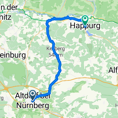
St2401 22, Altdorf bei Nürnberg nach Am Rascher Berg 22, Altdorf bei Nürnberg
A cycling route starting in Altdorf bei Nürnberg, Bavaria, Germany.
Overview
About this route
- 1 h 48 min
- Duration
- 32.6 km
- Distance
- 336 m
- Ascent
- 330 m
- Descent
- 18.1 km/h
- Avg. speed
- ---
- Max. altitude
Route quality
Waytypes & surfaces along the route
Waytypes
Track
11.1 km
(34 %)
Quiet road
6.5 km
(20 %)
Surfaces
Paved
17.1 km
(52 %)
Unpaved
14.3 km
(44 %)
Asphalt
15.4 km
(47 %)
Gravel
11.1 km
(34 %)
Continue with Bikemap
Use, edit, or download this cycling route
You would like to ride St2401 22, Altdorf bei Nürnberg nach Am Rascher Berg 22, Altdorf bei Nürnberg or customize it for your own trip? Here is what you can do with this Bikemap route:
Free features
- Save this route as favorite or in collections
- Copy & plan your own version of this route
- Sync your route with Garmin or Wahoo
Premium features
Free trial for 3 days, or one-time payment. More about Bikemap Premium.
- Navigate this route on iOS & Android
- Export a GPX / KML file of this route
- Create your custom printout (try it for free)
- Download this route for offline navigation
Discover more Premium features.
Get Bikemap PremiumFrom our community
Other popular routes starting in Altdorf bei Nürnberg
 RR - Altdorf 3 Berge Tour
- Distance
- 48 km
- Ascent
- 794 m
- Descent
- 810 m
- Location
- Altdorf bei Nürnberg, Bavaria, Germany
 Cross/MTB Altdorf - Amberg
- Distance
- 51.7 km
- Ascent
- 634 m
- Descent
- 696 m
- Location
- Altdorf bei Nürnberg, Bavaria, Germany
 Kiliansgasse 12a, Altdorf bei Nürnberg nach Untere Mühlstraße 1, Happurg
- Distance
- 24.9 km
- Ascent
- 253 m
- Descent
- 342 m
- Location
- Altdorf bei Nürnberg, Bavaria, Germany
 F50O39Altdorf-Traunfeld-Runde
- Distance
- 39 km
- Ascent
- 456 m
- Descent
- 453 m
- Location
- Altdorf bei Nürnberg, Bavaria, Germany
 Teufelskirche – Emils Brunnen Runde von Altdorf (b Nürnberg)
- Distance
- 11.8 km
- Ascent
- 128 m
- Descent
- 126 m
- Location
- Altdorf bei Nürnberg, Bavaria, Germany
 Altdorf-Feucht-Nürnberg-Schwaig-Altdorf
- Distance
- 49.8 km
- Ascent
- 205 m
- Descent
- 205 m
- Location
- Altdorf bei Nürnberg, Bavaria, Germany
 Altdorf-Diepersdorf-Altdorf durch den Wald
- Distance
- 40 km
- Ascent
- 273 m
- Descent
- 275 m
- Location
- Altdorf bei Nürnberg, Bavaria, Germany
 Feucht Schwand Postbauer 61 470
- Distance
- 61.8 km
- Ascent
- 420 m
- Descent
- 421 m
- Location
- Altdorf bei Nürnberg, Bavaria, Germany
Open it in the app