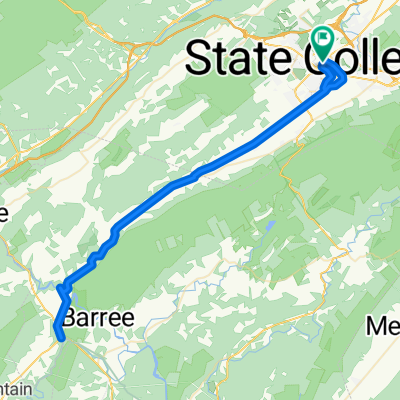
Allegheny front loop
A cycling route starting in State College, Pennsylvania, United States of America.
Overview
About this route
- -:--
- Duration
- 51.7 km
- Distance
- 852 m
- Ascent
- 854 m
- Descent
- ---
- Avg. speed
- ---
- Avg. speed
Route quality
Waytypes & surfaces along the route
Waytypes
Road
22 km
(43 %)
Quiet road
13.9 km
(27 %)
Surfaces
Paved
43.5 km
(84 %)
Unpaved
7.9 km
(15 %)
Asphalt
43.1 km
(83 %)
Gravel
2.7 km
(5 %)
Continue with Bikemap
Use, edit, or download this cycling route
You would like to ride Allegheny front loop or customize it for your own trip? Here is what you can do with this Bikemap route:
Free features
- Save this route as favorite or in collections
- Copy & plan your own version of this route
- Sync your route with Garmin or Wahoo
Premium features
Free trial for 3 days, or one-time payment. More about Bikemap Premium.
- Navigate this route on iOS & Android
- Export a GPX / KML file of this route
- Create your custom printout (try it for free)
- Download this route for offline navigation
Discover more Premium features.
Get Bikemap PremiumFrom our community
Other popular routes starting in State College
- Snow Shoe Loop
- Distance
- 121.2 km
- Ascent
- 980 m
- Descent
- 980 m
- Location
- State College, Pennsylvania, United States of America
- Spring Creek Canyon Loop
- Distance
- 37.3 km
- Ascent
- 245 m
- Descent
- 244 m
- Location
- State College, Pennsylvania, United States of America
- Allegheny front loop
- Distance
- 51.7 km
- Ascent
- 852 m
- Descent
- 854 m
- Location
- State College, Pennsylvania, United States of America
- Purdue Mountain Loop
- Distance
- 48.2 km
- Ascent
- 509 m
- Descent
- 509 m
- Location
- State College, Pennsylvania, United States of America
- Bike 12 miles
- Distance
- 19.9 km
- Ascent
- 195 m
- Descent
- 188 m
- Location
- State College, Pennsylvania, United States of America
- State College-Bellefonte
- Distance
- 20.6 km
- Ascent
- 378 m
- Descent
- 492 m
- Location
- State College, Pennsylvania, United States of America
- Allegheny Front loop
- Distance
- 61.8 km
- Ascent
- 870 m
- Descent
- 872 m
- Location
- State College, Pennsylvania, United States of America
- Scenic Town/Farm route and Baileyville
- Distance
- 45.7 km
- Ascent
- 222 m
- Descent
- 222 m
- Location
- State College, Pennsylvania, United States of America
Open it in the app