
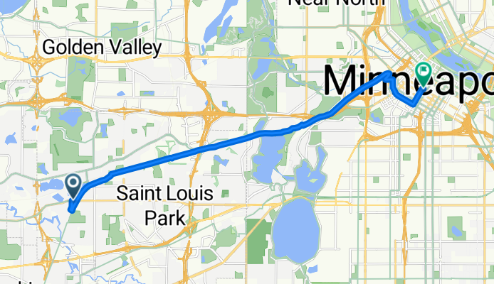
B2B00532 55426>55402 via Cedar Lake Trl, 10th St
A cycling route starting in Saint Louis Park, Minnesota, United States.
Overview
About this route
Bike lanes on 2nd Ave run opposite of traffic.
To return to Cedar Lake Trl, take S6th St to 3rd Ave S (heading south), turn onto S7th St and then take the bike lanes running opposite of traffic on Marquette Av. Take to 11th St, which you can take to the intersection where the trail begins.
- -:--
- Duration
- 11.9 km
- Distance
- 61 m
- Ascent
- 55 m
- Descent
- ---
- Avg. speed
- ---
- Max. altitude
Route highlights
Points of interest along the route
Point of interest after 0.3 km
Entrance onto trail
Continue with Bikemap
Use, edit, or download this cycling route
You would like to ride B2B00532 55426>55402 via Cedar Lake Trl, 10th St or customize it for your own trip? Here is what you can do with this Bikemap route:
Free features
- Save this route as favorite or in collections
- Copy & plan your own version of this route
- Sync your route with Garmin or Wahoo
Premium features
Free trial for 3 days, or one-time payment. More about Bikemap Premium.
- Navigate this route on iOS & Android
- Export a GPX / KML file of this route
- Create your custom printout (try it for free)
- Download this route for offline navigation
Discover more Premium features.
Get Bikemap PremiumFrom our community
Other popular routes starting in Saint Louis Park
 Regional Trail Loop St. Louis Park
- Distance
- 21.1 km
- Ascent
- 61 m
- Descent
- 63 m
- Location
- Saint Louis Park, Minnesota, United States
 Kid Taxi ft. Roller Coaster Hill
- Distance
- 7.6 km
- Ascent
- 61 m
- Descent
- 52 m
- Location
- Saint Louis Park, Minnesota, United States
 Possible bike tour
- Distance
- 880.9 km
- Ascent
- 1,461 m
- Descent
- 1,448 m
- Location
- Saint Louis Park, Minnesota, United States
 River Bottoms Loop
- Distance
- 79.2 km
- Ascent
- 457 m
- Descent
- 460 m
- Location
- Saint Louis Park, Minnesota, United States
 Sunday Route
- Distance
- 34.4 km
- Ascent
- 88 m
- Descent
- 88 m
- Location
- Saint Louis Park, Minnesota, United States
 Uptown, Lake Nokomis, Mississippi River, Greenway
- Distance
- 27.7 km
- Ascent
- 63 m
- Descent
- 62 m
- Location
- Saint Louis Park, Minnesota, United States
 minnehaha falls round trip
- Distance
- 30 km
- Ascent
- 67 m
- Descent
- 74 m
- Location
- Saint Louis Park, Minnesota, United States
 Lengthy bike tour through Minneapolis
- Distance
- 38.1 km
- Ascent
- 91 m
- Descent
- 93 m
- Location
- Saint Louis Park, Minnesota, United States
Open it in the app