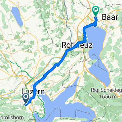
Stans - Sarnen
A cycling route starting in Kriens, Canton of Lucerne, Switzerland.
Overview
About this route
- -:--
- Duration
- 48 km
- Distance
- 291 m
- Ascent
- 291 m
- Descent
- ---
- Avg. speed
- ---
- Avg. speed
Route quality
Waytypes & surfaces along the route
Waytypes
Busy road
24.2 km
(50 %)
Cycleway
10.7 km
(22 %)
Surfaces
Paved
26 km
(54 %)
Unpaved
2.7 km
(6 %)
Asphalt
25.4 km
(53 %)
Gravel
2.1 km
(4 %)
Continue with Bikemap
Use, edit, or download this cycling route
You would like to ride Stans - Sarnen or customize it for your own trip? Here is what you can do with this Bikemap route:
Free features
- Save this route as favorite or in collections
- Copy & plan your own version of this route
- Sync your route with Garmin or Wahoo
Premium features
Free trial for 3 days, or one-time payment. More about Bikemap Premium.
- Navigate this route on iOS & Android
- Export a GPX / KML file of this route
- Create your custom printout (try it for free)
- Download this route for offline navigation
Discover more Premium features.
Get Bikemap PremiumFrom our community
Other popular routes starting in Kriens
- Stans - Sarnen
- Distance
- 48 km
- Ascent
- 291 m
- Descent
- 291 m
- Location
- Kriens, Canton of Lucerne, Switzerland
- Krienseregg-gütsch
- Distance
- 14.7 km
- Ascent
- 693 m
- Descent
- 714 m
- Location
- Kriens, Canton of Lucerne, Switzerland
- Pilatus MTB
- Distance
- 60.4 km
- Ascent
- 2,280 m
- Descent
- 2,281 m
- Location
- Kriens, Canton of Lucerne, Switzerland
- Auffahrt Etappe 3
- Distance
- 62.5 km
- Ascent
- 305 m
- Descent
- 346 m
- Location
- Kriens, Canton of Lucerne, Switzerland
- geili rundi
- Distance
- 83.2 km
- Ascent
- 763 m
- Descent
- 765 m
- Location
- Kriens, Canton of Lucerne, Switzerland
- Kriens - Sursee - Schenkon - Hildisrieden - Kriens
- Distance
- 59.1 km
- Ascent
- 557 m
- Descent
- 557 m
- Location
- Kriens, Canton of Lucerne, Switzerland
- CH Luzerner Trainingsrunde
- Distance
- 125.9 km
- Ascent
- 1,328 m
- Descent
- 1,325 m
- Location
- Kriens, Canton of Lucerne, Switzerland
- 4-Waldstätter Fahrt
- Distance
- 57.6 km
- Ascent
- 969 m
- Descent
- 970 m
- Location
- Kriens, Canton of Lucerne, Switzerland