

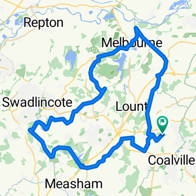
Coalvile - Packington - Normanton le Heath Loop
A cycling route starting in Coalville, England, United Kingdom.
Overview
About this route
Nice steady loop out of Coalville towards Ashby, then turn through Packington, across to Normanton le Heath and back into Coalville via Ravenstone.
- -:--
- Duration
- 17.9 km
- Distance
- 118 m
- Ascent
- 116 m
- Descent
- ---
- Avg. speed
- ---
- Max. altitude

Route quality
Waytypes & surfaces along the route
Waytypes
Road
9.5 km
(53 %)
Quiet road
8.4 km
(47 %)
Surfaces
Paved
6.1 km
(34 %)
Asphalt
6.1 km
(34 %)
Undefined
11.8 km
(66 %)
Continue with Bikemap
Use, edit, or download this cycling route
You would like to ride Coalvile - Packington - Normanton le Heath Loop or customize it for your own trip? Here is what you can do with this Bikemap route:
Free features
- Save this route as favorite or in collections
- Copy & plan your own version of this route
- Sync your route with Garmin or Wahoo
Premium features
Free trial for 3 days, or one-time payment. More about Bikemap Premium.
- Navigate this route on iOS & Android
- Export a GPX / KML file of this route
- Create your custom printout (try it for free)
- Download this route for offline navigation
Discover more Premium features.
Get Bikemap PremiumFrom our community
Other popular routes starting in Coalville
 12 Barr Crescent, Coalville to 12 Barr Crescent, Coalville
- Distance
- 37.6 km
- Ascent
- 300 m
- Descent
- 300 m
- Location
- Coalville, England, United Kingdom
 Coalville Lane 33, Ravenstone to Coalville Lane 33, Ravenstone
- Distance
- 11.6 km
- Ascent
- 70 m
- Descent
- 115 m
- Location
- Coalville, England, United Kingdom
 Commute
- Distance
- 27.6 km
- Ascent
- 106 m
- Descent
- 211 m
- Location
- Coalville, England, United Kingdom
 Relaxed route in Coalville
- Distance
- 6.2 km
- Ascent
- 60 m
- Descent
- 45 m
- Location
- Coalville, England, United Kingdom
 Soar loop
- Distance
- 56.2 km
- Ascent
- 263 m
- Descent
- 263 m
- Location
- Coalville, England, United Kingdom
 Bardon Road 22 - 29/6/22
- Distance
- 7.3 km
- Ascent
- 24 m
- Descent
- 74 m
- Location
- Coalville, England, United Kingdom
 3/6/22
- Distance
- 53 km
- Ascent
- 387 m
- Descent
- 411 m
- Location
- Coalville, England, United Kingdom
 Conkers_Calke_and_Cloud2
- Distance
- 54.2 km
- Ascent
- 351 m
- Descent
- 351 m
- Location
- Coalville, England, United Kingdom
Open it in the app