RTF Route 1 Polcher
A cycling route starting in Polch, Rhineland-Palatinate, Germany.
Overview
About this route
Von Polch über die Landstrasse nach Mertloch. Dann weiter über Gappenach, Dreckenach zur Mosel. In Kobern-Gondorf geht es über die Mosel, um dann auf der anderen Moselseite Flußaufwärts die Mosel bei Löf zu überqueren. Dann weiter bis nach Hatzenport und über die normale Landstrasse (nicht Schrumpftal) den Hatzenporter Berg 10% Steigung auf 1,5 km nach Münstermaifeld und zurück nach Polch.
- -:--
- Duration
- 40 km
- Distance
- 340 m
- Ascent
- 336 m
- Descent
- ---
- Avg. speed
- 256 m
- Max. altitude
Route quality
Waytypes & surfaces along the route
Waytypes
Road
6.4 km
(16 %)
Quiet road
6 km
(15 %)
Surfaces
Paved
23.2 km
(58 %)
Asphalt
23.2 km
(58 %)
Undefined
16.8 km
(42 %)
Continue with Bikemap
Use, edit, or download this cycling route
You would like to ride RTF Route 1 Polcher or customize it for your own trip? Here is what you can do with this Bikemap route:
Free features
- Save this route as favorite or in collections
- Copy & plan your own version of this route
- Sync your route with Garmin or Wahoo
Premium features
Free trial for 3 days, or one-time payment. More about Bikemap Premium.
- Navigate this route on iOS & Android
- Export a GPX / KML file of this route
- Create your custom printout (try it for free)
- Download this route for offline navigation
Discover more Premium features.
Get Bikemap PremiumFrom our community
Other popular routes starting in Polch
Polch nach Zur Mühle- Distance
- 105.3 km
- Ascent
- 1,766 m
- Descent
- 1,496 m
- Location
- Polch, Rhineland-Palatinate, Germany
Polch-Kobern-Hatzenport-Polch- Distance
- 44.1 km
- Ascent
- 405 m
- Descent
- 405 m
- Location
- Polch, Rhineland-Palatinate, Germany
Laachersee Tour- Distance
- 42.3 km
- Ascent
- 801 m
- Descent
- 798 m
- Location
- Polch, Rhineland-Palatinate, Germany
20150729_060217.gpx- Distance
- 7.1 km
- Ascent
- 84 m
- Descent
- 88 m
- Location
- Polch, Rhineland-Palatinate, Germany
Hunsrück Rhein Mosel Tour 80 km- Distance
- 78.8 km
- Ascent
- 919 m
- Descent
- 916 m
- Location
- Polch, Rhineland-Palatinate, Germany
RTF Route 1 Polcher- Distance
- 40 km
- Ascent
- 340 m
- Descent
- 336 m
- Location
- Polch, Rhineland-Palatinate, Germany
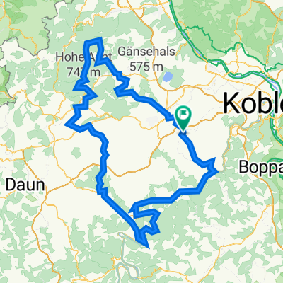
Maifeld - Mosel - RTF des VfB Polch e.V. Abt. Radsport - 45 km Strecke (bis 2015)- Distance
- 42.1 km
- Ascent
- 310 m
- Descent
- 310 m
- Location
- Polch, Rhineland-Palatinate, Germany
Thür-Ochtendung- Distance
- 32 km
- Ascent
- 308 m
- Descent
- 306 m
- Location
- Polch, Rhineland-Palatinate, Germany
Open it in the app


