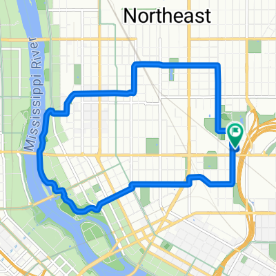
B2B00715 55406 > 55402 via Midtown Greenway, Park Ave
A cycling route starting in Lauderdale, Minnesota, United States.
Overview
About this route
Park Ave has a dedicated bike lane all the way to S 9th St, which also has a dedicated bike lane to LaSalle Ave. Approx. 6 miles each way.
- -:--
- Duration
- 9 km
- Distance
- 15 m
- Ascent
- 3 m
- Descent
- ---
- Avg. speed
- 263 m
- Max. altitude
Route quality
Waytypes & surfaces along the route
Waytypes
Road
5.2 km
(58 %)
Cycleway
3.5 km
(39 %)
Quiet road
0.2 km
(3 %)
Surfaces
Paved
5.9 km
(66 %)
Asphalt
5.8 km
(64 %)
Concrete
0.1 km
(1 %)
Undefined
3.1 km
(34 %)
Route highlights
Points of interest along the route
Point of interest after 1 km
Enter onto the Midtown Greenway at E 27th St
Point of interest after 3.2 km
Trail users yield to traffic at this intersection
Point of interest after 3.7 km
Cross Hwy 55 on the Sabo Bridge
Point of interest after 4 km
Trail users yield to traffic at this intersection
Point of interest after 5.9 km
Exit onto Park Ave from the Greenway
Continue with Bikemap
Use, edit, or download this cycling route
You would like to ride B2B00715 55406 > 55402 via Midtown Greenway, Park Ave or customize it for your own trip? Here is what you can do with this Bikemap route:
Free features
- Save this route as favorite or in collections
- Copy & plan your own version of this route
- Sync your route with Garmin or Wahoo
Premium features
Free trial for 3 days, or one-time payment. More about Bikemap Premium.
- Navigate this route on iOS & Android
- Export a GPX / KML file of this route
- Create your custom printout (try it for free)
- Download this route for offline navigation
Discover more Premium features.
Get Bikemap PremiumFrom our community
Other popular routes starting in Lauderdale
- St Paul Circle Tour
- Distance
- 36.9 km
- Ascent
- 140 m
- Descent
- 142 m
- Location
- Lauderdale, Minnesota, United States
- B2B00900 55113>55104 via Fairview Av, Como Av
- Distance
- 10.1 km
- Ascent
- 22 m
- Descent
- 36 m
- Location
- Lauderdale, Minnesota, United States
- Minneapolis Route
- Distance
- 27.6 km
- Ascent
- 136 m
- Descent
- 137 m
- Location
- Lauderdale, Minnesota, United States
- Surley Downtown Route
- Distance
- 67.1 km
- Ascent
- 508 m
- Descent
- 509 m
- Location
- Lauderdale, Minnesota, United States
- Fort Snelling Loop
- Distance
- 20.9 km
- Ascent
- 169 m
- Descent
- 154 m
- Location
- Lauderdale, Minnesota, United States
- B2B00051 55108>55345 via CLT, SWLRT Trls
- Distance
- 27.8 km
- Ascent
- 128 m
- Descent
- 94 m
- Location
- Lauderdale, Minnesota, United States
- B2B00715 55406 > 55402 via Midtown Greenway, Park Ave
- Distance
- 9 km
- Ascent
- 15 m
- Descent
- 3 m
- Location
- Lauderdale, Minnesota, United States
- Lake Superior circumnavigation tour (proposed)
- Distance
- 2,032.5 km
- Ascent
- 1,521 m
- Descent
- 1,564 m
- Location
- Lauderdale, Minnesota, United States
Open it in the app