

Rute Alicantina
A cycling route starting in Altea, Valencia, Spain.
Overview
About this route
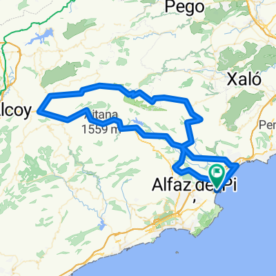
Altea, Callosa de Ensarriá, Taberna, Parcent, Alcalalí, Llosa de Camacho, Pedreguer, Gata de Gorgos, Lliber, Jalón, Sierra de Bernia and Ferrer, Benicolada direction Calpe, via the National 332, Canuta, Pueblo Mascarat, Altea.
- -:--
- Duration
- 102.5 km
- Distance
- 2,620 m
- Ascent
- 2,618 m
- Descent
- ---
- Avg. speed
- ---
- Max. altitude

Route photos


Continue with Bikemap
Use, edit, or download this cycling route
You would like to ride Rute Alicantina or customize it for your own trip? Here is what you can do with this Bikemap route:
Free features
- Save this route as favorite or in collections
- Copy & plan your own version of this route
- Split it into stages to create a multi-day tour
- Sync your route with Garmin or Wahoo
Premium features
Free trial for 3 days, or one-time payment. More about Bikemap Premium.
- Navigate this route on iOS & Android
- Export a GPX / KML file of this route
- Create your custom printout (try it for free)
- Download this route for offline navigation
Discover more Premium features.
Get Bikemap PremiumFrom our community
Other popular routes starting in Altea
 La Marina Baixa: l'Albir-Altea-far de l'Albir
- Distance
- 13.2 km
- Ascent
- 198 m
- Descent
- 197 m
- Location
- Altea, Valencia, Spain
 Salida Altea-Confrides
- Distance
- 106.8 km
- Ascent
- 1,288 m
- Descent
- 1,281 m
- Location
- Altea, Valencia, Spain
 Altea - Benitato - La Nucia
- Distance
- 52.5 km
- Ascent
- 751 m
- Descent
- 756 m
- Location
- Altea, Valencia, Spain
 La Vall de Laguar
- Distance
- 153.3 km
- Ascent
- 2,249 m
- Descent
- 2,246 m
- Location
- Altea, Valencia, Spain
 Cycle to Spain - Day 18 - 27/04/15
- Distance
- 158.6 km
- Ascent
- 426 m
- Descent
- 413 m
- Location
- Altea, Valencia, Spain
 De Ä„9÷? à Ä„9÷?
- Distance
- 11.6 km
- Ascent
- 0 m
- Descent
- 3 m
- Location
- Altea, Valencia, Spain
 T40 ALTEA-TABERNA-CONFRIDES-ALTEA
- Distance
- 112.1 km
- Ascent
- 1,608 m
- Descent
- 1,608 m
- Location
- Altea, Valencia, Spain
 R-1 Faro Albir
- Distance
- 17.7 km
- Ascent
- 210 m
- Descent
- 209 m
- Location
- Altea, Valencia, Spain
Open it in the app