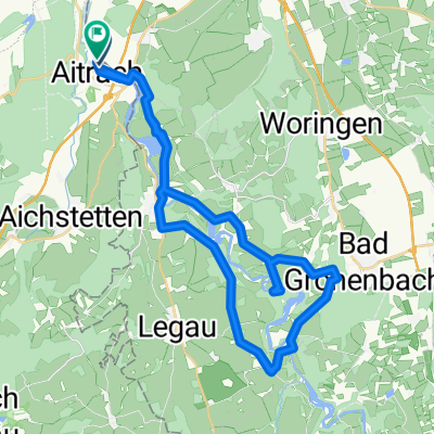
BW-12 Etappe 12 - Marstetten Aitrach - Ulm
A cycling route starting in Aitrach, Baden-Wurttemberg, Germany.
Overview
About this route
In the floodplain forests of the Iller Valley
Monasteries once flourished in the Iller Valley: from the Iller Valley cycle path, we make a small detour to the baroque Rot an der Rot and Bonlanden. The final stage to Ulm is completely flat and can be cycled comfortably. The route along the Iller passes through extensive floodplain forests, on finely gravelled paths through a quiet, green paradise. At the destination, we are rewarded with a magnificent view from the Danube bank of Ulm's old town and the impressive cathedral.
- -:--
- Duration
- 68 km
- Distance
- 91 m
- Ascent
- 215 m
- Descent
- ---
- Avg. speed
- ---
- Max. altitude
Route quality
Waytypes & surfaces along the route
Waytypes
Track
32.7 km
(48 %)
Path
16.3 km
(24 %)
Surfaces
Paved
22.5 km
(33 %)
Unpaved
32.7 km
(48 %)
Gravel
25.9 km
(38 %)
Asphalt
22.5 km
(33 %)
Continue with Bikemap
Use, edit, or download this cycling route
You would like to ride BW-12 Etappe 12 - Marstetten Aitrach - Ulm or customize it for your own trip? Here is what you can do with this Bikemap route:
Free features
- Save this route as favorite or in collections
- Copy & plan your own version of this route
- Sync your route with Garmin or Wahoo
Premium features
Free trial for 3 days, or one-time payment. More about Bikemap Premium.
- Navigate this route on iOS & Android
- Export a GPX / KML file of this route
- Create your custom printout (try it for free)
- Download this route for offline navigation
Discover more Premium features.
Get Bikemap PremiumFrom our community
Other popular routes starting in Aitrach
- BW-12 Etappe 12 - Marstetten Aitrach - Ulm
- Distance
- 68 km
- Ascent
- 91 m
- Descent
- 215 m
- Location
- Aitrach, Baden-Wurttemberg, Germany
- Radreise zum Bodensee: 5. Tag – Von Aitrach nach Lindau
- Distance
- 71.4 km
- Ascent
- 366 m
- Descent
- 556 m
- Location
- Aitrach, Baden-Wurttemberg, Germany
- Aitrach - Erolzheim - Aitrach
- Distance
- 61 km
- Ascent
- 390 m
- Descent
- 390 m
- Location
- Aitrach, Baden-Wurttemberg, Germany
- Illertal - Rothtal - Günztal - Runde
- Distance
- 90.8 km
- Ascent
- 232 m
- Descent
- 233 m
- Location
- Aitrach, Baden-Wurttemberg, Germany
- Rund um Memmingen
- Distance
- 64.5 km
- Ascent
- 316 m
- Descent
- 318 m
- Location
- Aitrach, Baden-Wurttemberg, Germany
- 33 "-hofen"-Tour
- Distance
- 81.6 km
- Ascent
- 431 m
- Descent
- 431 m
- Location
- Aitrach, Baden-Wurttemberg, Germany
- Kronburg - Feierabendrunde mit Biergarten
- Distance
- 24.2 km
- Ascent
- 204 m
- Descent
- 205 m
- Location
- Aitrach, Baden-Wurttemberg, Germany
- Aitrach - Diepoldshofen - Seibranz - Rot/Rot - Aitrach
- Distance
- 55 km
- Ascent
- 306 m
- Descent
- 303 m
- Location
- Aitrach, Baden-Wurttemberg, Germany
Open it in the app