

Römerstrasse
A cycling route starting in Seedorf, Baden-Wurttemberg, Germany.
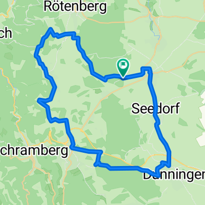
Overview
About this route
From Waldmössingen, the tour passes by the Roman castle along the Roman road to Hochmössingen and further to Fluorn and Winzeln. Again over the Roman road, it goes to Rötenberg and past the former Roman road station Brandsteig back to Waldmössingen.
- -:--
- Duration
- 32.4 km
- Distance
- 270 m
- Ascent
- 270 m
- Descent
- ---
- Avg. speed
- ---
- Max. altitude

Route quality
Waytypes & surfaces along the route
Waytypes
Track
15.9 km
(49 %)
Quiet road
8.1 km
(25 %)
Surfaces
Paved
23.3 km
(72 %)
Unpaved
6.5 km
(20 %)
Asphalt
15.5 km
(48 %)
Paved (undefined)
7.8 km
(24 %)
Continue with Bikemap
Use, edit, or download this cycling route
You would like to ride Römerstrasse or customize it for your own trip? Here is what you can do with this Bikemap route:
Free features
- Save this route as favorite or in collections
- Copy & plan your own version of this route
- Sync your route with Garmin or Wahoo
Premium features
Free trial for 3 days, or one-time payment. More about Bikemap Premium.
- Navigate this route on iOS & Android
- Export a GPX / KML file of this route
- Create your custom printout (try it for free)
- Download this route for offline navigation
Discover more Premium features.
Get Bikemap PremiumFrom our community
Other popular routes starting in Seedorf
 Seedorf - Schonach - Gutach - Aichhalden
- Distance
- 94.5 km
- Ascent
- 1,308 m
- Descent
- 1,565 m
- Location
- Seedorf, Baden-Wurttemberg, Germany
 Seedorf - Hardt - Furtwangen (Genussrunde)
- Distance
- 70.5 km
- Ascent
- 913 m
- Descent
- 805 m
- Location
- Seedorf, Baden-Wurttemberg, Germany
 Seedorf - Eschachtal - Hohenkarpfen - Klippeneck
- Distance
- 102 km
- Ascent
- 1,003 m
- Descent
- 1,002 m
- Location
- Seedorf, Baden-Wurttemberg, Germany
 Von Waldmössingen durch die Gäulandschaft
- Distance
- 45.4 km
- Ascent
- 287 m
- Descent
- 279 m
- Location
- Seedorf, Baden-Wurttemberg, Germany
 Waldmössingen Rottweil Neckartal Oberndorf zurück
- Distance
- 31.5 km
- Ascent
- 382 m
- Descent
- 382 m
- Location
- Seedorf, Baden-Wurttemberg, Germany
 Waldmössingen-Flugplatz Winzeln-Rötenberg-Aichhalden-Sulgen-Beschenhof-Dunningen-Seedorf-Waldmössingen
- Distance
- 34.8 km
- Ascent
- 238 m
- Descent
- 238 m
- Location
- Seedorf, Baden-Wurttemberg, Germany
 Seedorf-Tennenbronn-Mosenmättle
- Distance
- 62.6 km
- Ascent
- 1,386 m
- Descent
- 1,373 m
- Location
- Seedorf, Baden-Wurttemberg, Germany
 Neckartalrunde
- Distance
- 50.9 km
- Ascent
- 428 m
- Descent
- 428 m
- Location
- Seedorf, Baden-Wurttemberg, Germany
Open it in the app