30km/flat/Strumień-Jarząbkowice-Ochaby-Drogomyśl-Strumień
A cycling route starting in Strumień, Silesian Voivodeship, Poland.
Overview
About this route
- -:--
- Duration
- 29.8 km
- Distance
- 56 m
- Ascent
- 56 m
- Descent
- ---
- Avg. speed
- ---
- Avg. speed
Route quality
Waytypes & surfaces along the route
Waytypes
Road
18.1 km
(61 %)
Quiet road
8.4 km
(28 %)
Surfaces
Paved
24.8 km
(83 %)
Unpaved
0.4 km
(1 %)
Asphalt
24.6 km
(83 %)
Unpaved (undefined)
0.2 km
(<1 %)
Continue with Bikemap
Use, edit, or download this cycling route
You would like to ride 30km/flat/Strumień-Jarząbkowice-Ochaby-Drogomyśl-Strumień or customize it for your own trip? Here is what you can do with this Bikemap route:
Free features
- Save this route as favorite or in collections
- Copy & plan your own version of this route
- Sync your route with Garmin or Wahoo
Premium features
Free trial for 3 days, or one-time payment. More about Bikemap Premium.
- Navigate this route on iOS & Android
- Export a GPX / KML file of this route
- Create your custom printout (try it for free)
- Download this route for offline navigation
Discover more Premium features.
Get Bikemap PremiumFrom our community
Other popular routes starting in Strumień
- 25km/flat/Drogomyśl-Ochaby-Gołysz-Strumień
- Distance
- 24.6 km
- Ascent
- 24 m
- Descent
- 24 m
- Location
- Strumień, Silesian Voivodeship, Poland
- 30km Na budowę i powrót stawami
- Distance
- 29.8 km
- Ascent
- 44 m
- Descent
- 43 m
- Location
- Strumień, Silesian Voivodeship, Poland
- 30km/flat/Frelichów-Gołysz-Drogomyśl
- Distance
- 29.7 km
- Ascent
- 24 m
- Descent
- 24 m
- Location
- Strumień, Silesian Voivodeship, Poland
- 30km/flat/Strumień-Jarząbkowice-Ochaby-Drogomyśl-Strumień
- Distance
- 29.8 km
- Ascent
- 56 m
- Descent
- 56 m
- Location
- Strumień, Silesian Voivodeship, Poland
- Szlakiem solanki Zabłockiej
- Distance
- 45.9 km
- Ascent
- 95 m
- Descent
- 96 m
- Location
- Strumień, Silesian Voivodeship, Poland
- Brzegowa 1, Zabłocie do Rynek 15, Strumień
- Distance
- 48.7 km
- Ascent
- 79 m
- Descent
- 79 m
- Location
- Strumień, Silesian Voivodeship, Poland
- Dookoła Jeziora Goczałkowickiego
- Distance
- 52.1 km
- Ascent
- 108 m
- Descent
- 106 m
- Location
- Strumień, Silesian Voivodeship, Poland
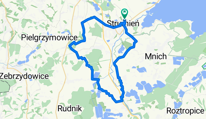
- Dookoła jez. Goczałkowickiego
- Distance
- 51.4 km
- Ascent
- 79 m
- Descent
- 79 m
- Location
- Strumień, Silesian Voivodeship, Poland
Open it in the app