

BTT 2020 - Secteur 1
A cycling route starting in Volvic, Auvergne-Rhône-Alpes, France.
Overview
About this route
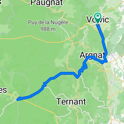
VOLVIC (Col / Puy de la Nugère) > CP1 Forêt de Murat (Col de La Molède) (Alt. 1329 m) Route Forestière de Sagnepic – 15300 Albepierre-Bredons
- -:--
- Duration
- 119.8 km
- Distance
- 2,923 m
- Ascent
- 2,480 m
- Descent
- ---
- Avg. speed
- ---
- Max. altitude

Route quality
Waytypes & surfaces along the route
Waytypes
Road
9.6 km
(8 %)
Quiet road
9.6 km
(8 %)
Undefined
100.6 km
(84 %)
Surfaces
Paved
67.1 km
(56 %)
Asphalt
67.1 km
(56 %)
Undefined
52.7 km
(44 %)
Continue with Bikemap
Use, edit, or download this cycling route
You would like to ride BTT 2020 - Secteur 1 or customize it for your own trip? Here is what you can do with this Bikemap route:
Free features
- Save this route as favorite or in collections
- Copy & plan your own version of this route
- Split it into stages to create a multi-day tour
- Sync your route with Garmin or Wahoo
Premium features
Free trial for 3 days, or one-time payment. More about Bikemap Premium.
- Navigate this route on iOS & Android
- Export a GPX / KML file of this route
- Create your custom printout (try it for free)
- Download this route for offline navigation
Discover more Premium features.
Get Bikemap PremiumFrom our community
Other popular routes starting in Volvic
 Volvic nach Vulcania
- Distance
- 29.2 km
- Ascent
- 532 m
- Descent
- 537 m
- Location
- Volvic, Auvergne-Rhône-Alpes, France
 Tour du Puy de Dôme
- Distance
- 61.2 km
- Ascent
- 1,358 m
- Descent
- 1,358 m
- Location
- Volvic, Auvergne-Rhône-Alpes, France
 La Dôme 2023
- Distance
- 62.7 km
- Ascent
- 1,366 m
- Descent
- 1,352 m
- Location
- Volvic, Auvergne-Rhône-Alpes, France
 BTT 2020
- Distance
- 537.8 km
- Ascent
- 12,610 m
- Descent
- 11,314 m
- Location
- Volvic, Auvergne-Rhône-Alpes, France
 La Volcane 2022
- Distance
- 160.1 km
- Ascent
- 3,395 m
- Descent
- 3,382 m
- Location
- Volvic, Auvergne-Rhône-Alpes, France
 La Volvic 2022 - La Volvic 2022
- Distance
- 97.7 km
- Ascent
- 1,854 m
- Descent
- 1,839 m
- Location
- Volvic, Auvergne-Rhône-Alpes, France
 Volvic Chambon
- Distance
- 83 km
- Ascent
- 1,696 m
- Descent
- 1,321 m
- Location
- Volvic, Auvergne-Rhône-Alpes, France
 Volvic nach Vulcania
- Distance
- 14.7 km
- Ascent
- 498 m
- Descent
- 46 m
- Location
- Volvic, Auvergne-Rhône-Alpes, France
Open it in the app